Distance between Saguara and Pusuma
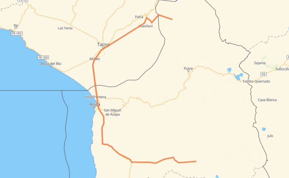
The distance from Saguara to Pusuma is 294 kilometers by road. Road takes approximately 4 hours and 59 minutes and goes through Arica, Zona Franca de Tacna, Codpa, Comedor de paso de Doña Rosita, Molles, Copare and Peschay.
| Shortest distance by air | 124 km ✈️ |
| Car route length | 294 km 🚗 |
| Driving time | 4 h 59 min |
| Fuel amount | 23.5 L |
| Fuel cost | 41.4 AUD |
| Point | Distance | Time | Fuel | |
| Saguara | 0 km | 00 min | 0.0 L | |
|
A-323 A-331 49 km, 39 min
|
||||
| Codpa | 49 km | 39 min | 3.7 L | |
|
A-35 75 km, 54 min
|
||||
| Arica | 124 km | 1 h 33 min | 6.6 L | |
|
5 PE-1S 43 km, 33 min
|
||||
| Comedor de paso de Doña Rosita | 167 km | 2 h 07 min | 13.3 L | |
|
PE-1S 22 km, 16 min
|
||||
| Molles | 189 km | 2 h 23 min | 14.9 L | |
|
PE-1S 4 km, 02 min
|
||||
| Zona Franca de Tacna | 192 km | 2 h 26 min | 15.3 L | |
|
PE-1S 3 km, 02 min
|
||||
| Copare | 196 km | 2 h 29 min | 15.5 L | |
|
PE-1S PE-40 8 km, 08 min
|
||||
| Peschay | 204 km | 2 h 37 min | 16.1 L | |
|
TA-631 TA-628 4 km, 04 min
|
||||
| Cerro Blanco | 208 km | 2 h 42 min | 16.6 L | |
|
TA-628 TA-600 104 km, 2 h 17 min
|
||||
| Pusuma | 312 km | 4 h 59 min | 25.0 L | |
Frequently Asked Questions
How much does it cost to drive from Saguara to Pusuma?
Fuel cost: 41.4 AUD
This fuel cost is calculated as: (Route length 294 km / 100 km) * (Fuel consumption 8 L/100 km) * (Fuel price 1.76 AUD / L)
You can adjust fuel consumption and fuel price here.
How long is a car ride from Saguara to Pusuma?
Driving time: 4 h 59 min
This time is calculated for driving at the maximum permitted speed, taking into account traffic rules restrictions.
- 65 km with a maximum speed 90 km/h = 43 min
- 154 km with a maximum speed 80 km/h = 1 h 55 min
- 8 km with a maximum speed 60 km/h = 8 min
- 67 km with a maximum speed 50 km/h = 1 h 20 min
- 17 km with a maximum speed 20 km/h = 51 min
The calculated driving time does not take into account intermediate stops and traffic jams.
How far is Saguara to Pusuma by land?
The distance between Saguara and Pusuma is 294 km by road.
Precise satellite coordinates of highways were used for this calculation. The start and finish points are the centers of Saguara and Pusuma respectively.
How far is Saguara to Pusuma by plane?
The shortest distance (air line, as the crow flies) between Saguara and Pusuma is 124 km.
This distance is calculated using the Haversine formula as a great-circle distance between two points on the surface of a sphere. The start and finish points are the centers of Saguara and Pusuma respectively. Actual distance between airports may be different.
How many hours is Saguara from Pusuma by plane?
Boeing 737 airliner needs 9 min to cover the distance of 124 km at a cruising speed of 800 km/h.
Small plane "Cessna 172" needs 33 min to flight this distance at average speed of 220 km/h.
This time is approximate and do not take into account takeoff and landing times, airport location and other real world factors.
How long is a helicopter ride from Saguara to Pusuma?
Fast helicopter "Eurocopter AS350" or "Hughes OH-6 Cayuse" need 31 min to cover the distance of 124 km at a cruising speed of 240 km/h.
Popular "Robinson R44" needs 35 min to flight this distance at average speed of 210 km/h.
This time is approximate and do not take into account takeoff and landing times, aerodrome location and other real world factors.
What city is halfway between Saguara and Pusuma?
The halfway point between Saguara and Pusuma is Comedor de paso de Doña Rosita. It is located about 19 km from the exact midpoint by road.
The distance from Comedor de paso de Doña Rosita to Saguara is 167 km and driving will take about 2 h 7 min. The road between Comedor de paso de Doña Rosita and Pusuma has length 128 km and will take approximately 2 h 52 min.
The other cities located close to halfway point:
Where is Saguara in relation to Pusuma?
Saguara is located 124 km south of Pusuma.
Saguara has geographic coordinates: latitude -18.89836, longitude -69.49444.
Pusuma has geographic coordinates: latitude -17.79954, longitude -69.68809.