Distance between San Gabriel Chilac and COL. MIGUEL DE LA MADRID
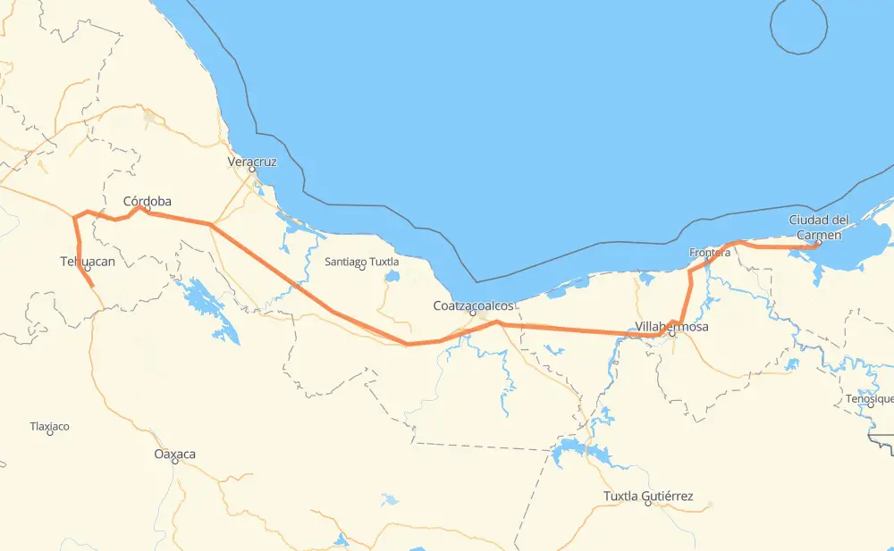
The distance from San Gabriel Chilac to COL. MIGUEL DE LA MADRID is 783 kilometers by road including 533 kilometers on motorways. Road takes approximately 8 hours and 37 minutes and goes through Orizaba, Santiago Miahuatlán, San José Ixtapa, Cuacnopalan, Maltrata, Nogales and Ixtaczoquitlán.
| Shortest distance by air | 585 km ✈️ |
| Car route length | 783 km 🚗 |
| Driving time | 8 h 37 min |
| Fuel amount | 62.6 L |
| Fuel cost | 111.5 AUD |
| Toll roads cost | 815 + ? MXN |
| Point | Distance | Time | Fuel | |
| San Gabriel Chilac | 0 km | 00 min | 0.0 L | |
|
MEX 135D 37 km, 25 min
|
||||
| Santiago Miahuatlán | 37 km | 25 min | 2.3 L | |
|
MEX 135D 15 km, 11 min
|
||||
| San José Ixtapa | 52 km | 36 min | 3.6 L | |
|
MEX 135D 12 km, 08 min
|
||||
| Cuacnopalan | 64 km | 45 min | 4.7 L | |
|
MEX 150D 26 km, 19 min
|
||||
| Maltrata | 90 km | 1 h 04 min | 7.1 L | |
|
MEX 150D 25 km, 18 min
|
||||
| Nogales | 115 km | 1 h 23 min | 8.9 L | |
|
MEX 150D 7 km, 05 min
|
||||
| Orizaba | 122 km | 1 h 28 min | 9.4 L | |
|
MEX 150D 5 km, 03 min
|
||||
| Ixtaczoquitlán | 127 km | 1 h 32 min | 10.1 L | |
|
MEX 150D MEX 145D 429 km, 4 h 25 min
|
||||
| Heroica Cárdenas | 556 km | 5 h 57 min | 43.4 L | |
|
MEX 180 227 km, 2 h 40 min
|
||||
| COL. MIGUEL DE LA MADRID | 783 km | 8 h 37 min | 62.6 L | |
Frequently Asked Questions
How many toll booths are there from San Gabriel Chilac to COL. MIGUEL DE LA MADRID?
There are 10 toll booths between San Gabriel Chilac and COL. MIGUEL DE LA MADRID: Fortín, Cuitláhuac, Cosamaloapan, Acayucan, Antonio Dovali, Esperanza 27, Tehuacán, Sánchez Magallanes, Villahermosa Nacajuca and Zacatal.
How much does the toll booths cost from San Gabriel Chilac to COL. MIGUEL DE LA MADRID?
Toll roads cost: Tehuacán (45 MXN) + Esperanza 27 (140 MXN) + Fortín (33 MXN) + Cuitláhuac (114 MXN) + Cosamaloapan (229 MXN) + Acayucan (?) + Antonio Dovali (20 MXN) + Sánchez Magallanes (82 MXN) + Villahermosa Nacajuca (62 MXN) + Zacatal (90 MXN) = 815 + ? MXN
How much does it cost to drive from San Gabriel Chilac to COL. MIGUEL DE LA MADRID?
Fuel cost: 111.5 AUD
This fuel cost is calculated as: (Route length 783 km / 100 km) * (Fuel consumption 8 L/100 km) * (Fuel price 1.78 AUD / L)
You can adjust fuel consumption and fuel price here.
Toll roads cost: 815 + ? MXN
How long is a car ride from San Gabriel Chilac to COL. MIGUEL DE LA MADRID?
Driving time: 8 h 37 min
This time is calculated for driving at the maximum permitted speed, taking into account traffic rules restrictions.
- 61 km with a maximum speed 110 km/h = 33 min
- 323 km with a maximum speed 100 km/h = 3 h 13 min
- 108 km with a maximum speed 90 km/h = 1 h 11 min
- 291 km with a maximum speed 80 km/h = 3 h 38 min
The calculated driving time does not take into account intermediate stops and traffic jams.
How far is San Gabriel Chilac to COL. MIGUEL DE LA MADRID by land?
The distance between San Gabriel Chilac and COL. MIGUEL DE LA MADRID is 783 km by road including 533 km on motorways.
Precise satellite coordinates of highways were used for this calculation. The start and finish points are the centers of San Gabriel Chilac and COL. MIGUEL DE LA MADRID respectively.
How far is San Gabriel Chilac to COL. MIGUEL DE LA MADRID by plane?
The shortest distance (air line, as the crow flies) between San Gabriel Chilac and COL. MIGUEL DE LA MADRID is 585 km.
This distance is calculated using the Haversine formula as a great-circle distance between two points on the surface of a sphere. The start and finish points are the centers of San Gabriel Chilac and COL. MIGUEL DE LA MADRID respectively. Actual distance between airports may be different.
How many hours is San Gabriel Chilac from COL. MIGUEL DE LA MADRID by plane?
Boeing 737 airliner needs 43 min to cover the distance of 585 km at a cruising speed of 800 km/h.
Small plane "Cessna 172" needs 2 h 39 min to flight this distance at average speed of 220 km/h.
This time is approximate and do not take into account takeoff and landing times, airport location and other real world factors.
How long is a helicopter ride from San Gabriel Chilac to COL. MIGUEL DE LA MADRID?
Fast helicopter "Eurocopter AS350" or "Hughes OH-6 Cayuse" need 2 h 26 min to cover the distance of 585 km at a cruising speed of 240 km/h.
Popular "Robinson R44" needs 2 h 47 min to flight this distance at average speed of 210 km/h.
This time is approximate and do not take into account takeoff and landing times, aerodrome location and other real world factors.
What city is halfway between San Gabriel Chilac and COL. MIGUEL DE LA MADRID?
The halfway point between San Gabriel Chilac and COL. MIGUEL DE LA MADRID is San Pedro Mártir. It is located about 27 km from the exact midpoint by road.
The distance from San Pedro Mártir to San Gabriel Chilac is 419 km and driving will take about 4 h 26 min. The road between San Pedro Mártir and COL. MIGUEL DE LA MADRID has length 364 km and will take approximately 4 h 10 min.
The other cities located close to halfway point:
Where is San Gabriel Chilac in relation to COL. MIGUEL DE LA MADRID?
San Gabriel Chilac is located 585 km west of COL. MIGUEL DE LA MADRID.
San Gabriel Chilac has geographic coordinates: latitude 18.32617, longitude -97.34754.
COL. MIGUEL DE LA MADRID has geographic coordinates: latitude 18.64025, longitude -91.8118.
Which highway goes from San Gabriel Chilac to COL. MIGUEL DE LA MADRID?
The route from San Gabriel Chilac to COL. MIGUEL DE LA MADRID follows MEX 180, MEX 145D, MEX 150D.
Other minor sections pass along the road:
- MEX 180D: 87 km
- MEX 135D: 61 km