Distance between San Salvador el Seco and FRACC. PLAYA PALMAS
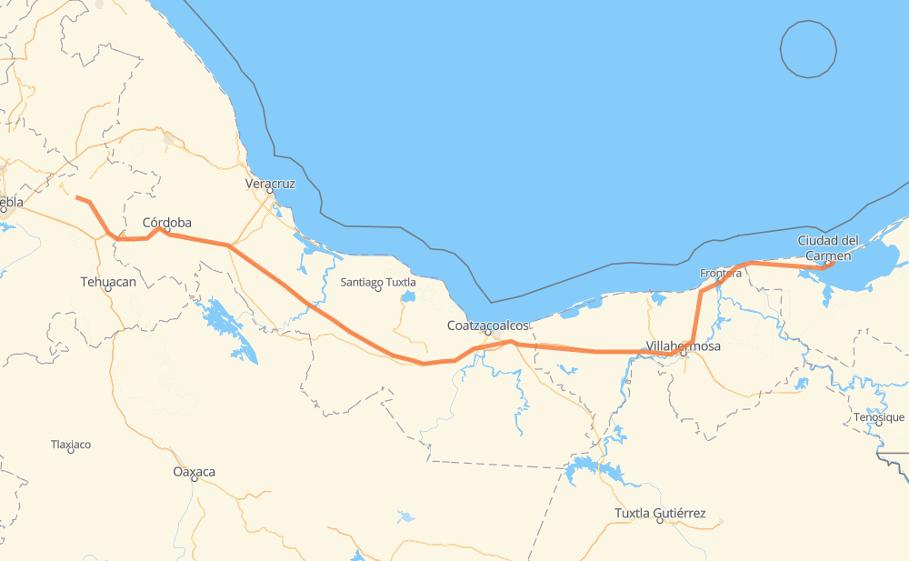
The distance from San Salvador el Seco to FRACC. PLAYA PALMAS is 760 kilometers by road including 459 kilometers on motorways. Road takes approximately 8 hours and 19 minutes and goes through Orizaba, Maltrata, Nogales, Ixtaczoquitlán, Heroica Cárdenas and Frontera.
| Shortest distance by air | 619 km ✈️ |
| Car route length | 760 km 🚗 |
| Driving time | 8 h 19 min |
| Fuel amount | 60.8 L |
| Fuel cost | 110 AUD |
| Toll roads cost | 702 + ? MXN |
| Point | Distance | Time | Fuel | |
| San Salvador el Seco | 0 km | 00 min | 0.0 L | |
|
MEX 144 6 km, 04 min
|
||||
| Santa María Coatepec | 6 km | 04 min | 0.4 L | |
|
MEX 144 8 km, 05 min
|
||||
| San Juan Atenco | 14 km | 10 min | 1.0 L | |
|
MEX 144 34 km, 22 min
|
||||
| Esperanza | 48 km | 32 min | 3.7 L | |
|
MEX 150D 12 km, 08 min
|
||||
| Maltrata | 59 km | 41 min | 4.6 L | |
|
MEX 150D 25 km, 18 min
|
||||
| Nogales | 84 km | 59 min | 6.5 L | |
|
MEX 150D 7 km, 05 min
|
||||
| Orizaba | 91 km | 1 h 04 min | 7.0 L | |
|
MEX 150D 5 km, 03 min
|
||||
| Ixtaczoquitlán | 96 km | 1 h 08 min | 7.6 L | |
|
MEX 150D MEX 145D 429 km, 4 h 25 min
|
||||
| Heroica Cárdenas | 526 km | 5 h 33 min | 40.9 L | |
|
MEX 180 138 km, 1 h 33 min
|
||||
| Frontera | 664 km | 7 h 07 min | 51.8 L | |
|
MEX 180 96 km, 1 h 11 min
|
||||
| 18.66639, -91.77704 | 760 km | 8 h 19 min | 60.8 L | |
Frequently Asked Questions
How many toll booths are there from San Salvador el Seco to FRACC. PLAYA PALMAS?
There are 9 toll booths between San Salvador el Seco and FRACC. PLAYA PALMAS: Fortín, Cuitláhuac, Cosamaloapan, Acayucan, Antonio Dovali, Esperanza 27, Sánchez Magallanes, Villahermosa Nacajuca and Zacatal.
How much does the toll booths cost from San Salvador el Seco to FRACC. PLAYA PALMAS?
Toll roads cost: Esperanza 27 (72 MXN) + Fortín (33 MXN) + Cuitláhuac (114 MXN) + Cosamaloapan (229 MXN) + Acayucan (?) + Antonio Dovali (20 MXN) + Sánchez Magallanes (82 MXN) + Villahermosa Nacajuca (62 MXN) + Zacatal (90 MXN) = 702 + ? MXN
How much does it cost to drive from San Salvador el Seco to FRACC. PLAYA PALMAS?
Fuel cost: 110 AUD
This fuel cost is calculated as: (Route length 760 km / 100 km) * (Fuel consumption 8 L/100 km) * (Fuel price 1.81 AUD / L)
You can adjust fuel consumption and fuel price here.
Toll roads cost: 702 + ? MXN
How long is a car ride from San Salvador el Seco to FRACC. PLAYA PALMAS?
Driving time: 8 h 19 min
This time is calculated for driving at the maximum permitted speed, taking into account traffic rules restrictions.
- 61 km with a maximum speed 110 km/h = 33 min
- 308 km with a maximum speed 100 km/h = 3 h 4 min
- 145 km with a maximum speed 90 km/h = 1 h 36 min
- 245 km with a maximum speed 80 km/h = 3 h 3 min
- 1 km with a maximum speed 50 km/h = 1 min
The calculated driving time does not take into account intermediate stops and traffic jams.
How far is San Salvador el Seco to FRACC. PLAYA PALMAS by land?
The distance between San Salvador el Seco and FRACC. PLAYA PALMAS is 760 km by road including 459 km on motorways.
Precise satellite coordinates of highways were used for this calculation. The start and finish points are the centers of San Salvador el Seco and FRACC. PLAYA PALMAS respectively.
How far is San Salvador el Seco to FRACC. PLAYA PALMAS by plane?
The shortest distance (air line, as the crow flies) between San Salvador el Seco and FRACC. PLAYA PALMAS is 619 km.
This distance is calculated using the Haversine formula as a great-circle distance between two points on the surface of a sphere. The start and finish points are the centers of San Salvador el Seco and FRACC. PLAYA PALMAS respectively. Actual distance between airports may be different.
How many hours is San Salvador el Seco from FRACC. PLAYA PALMAS by plane?
Boeing 737 airliner needs 46 min to cover the distance of 619 km at a cruising speed of 800 km/h.
Small plane "Cessna 172" needs 2 h 48 min to flight this distance at average speed of 220 km/h.
This time is approximate and do not take into account takeoff and landing times, airport location and other real world factors.
How long is a helicopter ride from San Salvador el Seco to FRACC. PLAYA PALMAS?
Fast helicopter "Eurocopter AS350" or "Hughes OH-6 Cayuse" need 2 h 34 min to cover the distance of 619 km at a cruising speed of 240 km/h.
Popular "Robinson R44" needs 2 h 56 min to flight this distance at average speed of 210 km/h.
This time is approximate and do not take into account takeoff and landing times, aerodrome location and other real world factors.
What city is halfway between San Salvador el Seco and FRACC. PLAYA PALMAS?
The halfway point between San Salvador el Seco and FRACC. PLAYA PALMAS is San Pedro Mártir. It is located about 8 km from the exact midpoint by road.
The distance from San Pedro Mártir to San Salvador el Seco is 388 km and driving will take about 4 h 3 min. The road between San Pedro Mártir and FRACC. PLAYA PALMAS has length 371 km and will take approximately 4 h 16 min.
The other cities located close to halfway point:
Where is San Salvador el Seco in relation to FRACC. PLAYA PALMAS?
San Salvador el Seco is located 619 km west of FRACC. PLAYA PALMAS.
San Salvador el Seco has geographic coordinates: latitude 19.13465, longitude -97.64181.
FRACC. PLAYA PALMAS has geographic coordinates: latitude 18.66639, longitude -91.77704.
Which highway goes from San Salvador el Seco to FRACC. PLAYA PALMAS?
The route from San Salvador el Seco to FRACC. PLAYA PALMAS follows MEX 180, MEX 145D, MEX 150D.
Other minor sections pass along the road:
- MEX 180D: 87 km
- MEX 144: 46 km