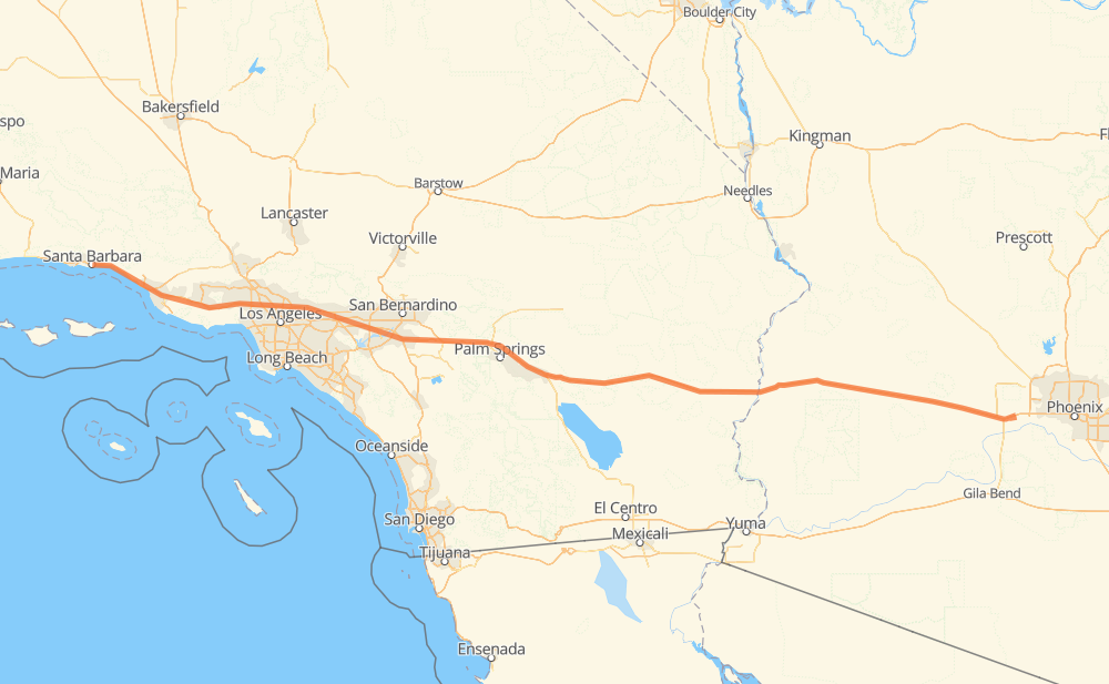
Distance between Santa Barbara CA and Windmill Village AZ
The distance from Santa Barbara to Windmill Village is 709 kilometers by road including 702 kilometers on motorways. Road takes approximately 6 hours and 48 minutes and goes through Ventura, Thousand Oaks, Los Angeles, Burbank, Glendale, Pasadena and Arcadia.
| Shortest distance by air | 671 km ✈️ |
| Car route length | 709 km 🚗 |
| Driving time | 6 h 48 min |
| Fuel amount | 56.7 L |
| Fuel cost | 101.5 AUD |
| Point | Distance | Time | Fuel | |
| Santa Barbara | 0 km | 00 min | 0.0 L | |
|
US 101 45 km, 26 min
|
||||
| Ventura | 45 km | 26 min | 3.3 L | |
|
US 101 42 km, 24 min
|
||||
| Thousand Oaks | 87 km | 51 min | 6.1 L | |
|
US 101 63 km, 36 min
|
||||
| Los Angeles | 150 km | 1 h 27 min | 8.6 L | |
|
US 101 46 km, 26 min
|
||||
| Pasadena | 196 km | 1 h 54 min | 15.3 L | |
|
I 210 7 km, 04 min
|
||||
| Arcadia | 203 km | 1 h 58 min | 16.0 L | |
|
I 210 4 km, 02 min
|
||||
| Monrovia | 207 km | 2 h 00 min | 16.4 L | |
|
I 210 9 km, 05 min
|
||||
| Azusa | 216 km | 2 h 05 min | 17.0 L | |
|
I 210 CA 57 19 km, 11 min
|
||||
| Pomona | 235 km | 2 h 17 min | 18.4 L | |
|
CA 71 8 km, 05 min
|
||||
| Chino | 243 km | 2 h 22 min | 19.2 L | |
|
CA 60 8 km, 05 min
|
||||
| Ontario | 251 km | 2 h 28 min | 19.7 L | |
|
CA 60 27 km, 17 min
|
||||
| Riverside | 278 km | 2 h 46 min | 21.7 L | |
|
CA 60 18 km, 12 min
|
||||
| Moreno Valley | 296 km | 2 h 59 min | 22.8 L | |
|
CA 60 I 10 52 km, 30 min
|
||||
| Palm Springs | 349 km | 3 h 30 min | 27.4 L | |
|
I 10 36 km, 19 min
|
||||
| Indio | 384 km | 3 h 49 min | 29.9 L | |
|
I 10 360 km, 3 h 18 min
|
||||
| Windmill Village | 744 km | 7 h 08 min | 59.3 L | |
Frequently Asked Questions
How much does it cost to drive from Santa Barbara to Windmill Village?
Fuel cost: 101.5 AUD
This fuel cost is calculated as: (Route length 709 km / 100 km) * (Fuel consumption 8 L/100 km) * (Fuel price 1.79 AUD / L)
You can adjust fuel consumption and fuel price here.
How long is a car ride from Santa Barbara to Windmill Village?
Driving time: 6 h 48 min
This time is calculated for driving at the maximum permitted speed, taking into account traffic rules restrictions.
- 420 km with a maximum speed 110 km/h = 3 h 49 min
- 194 km with a maximum speed 105 km/h = 1 h 51 min
- 19 km with a maximum speed 100 km/h = 11 min
- 24 km with a maximum speed 89 km/h = 16 min
- 46 km with a maximum speed 80 km/h = 34 min
- 3 km with a maximum speed 72 km/h = 2 min
- 1 km with a maximum speed 50 km/h = 1 min
- 1 km with a maximum speed 48 km/h = 1 min
The calculated driving time does not take into account intermediate stops and traffic jams.
How far is Santa Barbara to Windmill Village by land?
The distance between Santa Barbara and Windmill Village is 709 km by road including 702 km on motorways.
Precise satellite coordinates of highways were used for this calculation. The start and finish points are the centers of Santa Barbara and Windmill Village respectively.
How far is Santa Barbara to Windmill Village by plane?
The shortest distance (air line, as the crow flies) between Santa Barbara and Windmill Village is 671 km.
This distance is calculated using the Haversine formula as a great-circle distance between two points on the surface of a sphere. The start and finish points are the centers of Santa Barbara and Windmill Village respectively. Actual distance between airports may be different.
How many hours is Santa Barbara from Windmill Village by plane?
Boeing 737 airliner needs 50 min to cover the distance of 671 km at a cruising speed of 800 km/h.
Small plane "Cessna 172" needs 3 h 3 min to flight this distance at average speed of 220 km/h.
This time is approximate and do not take into account takeoff and landing times, airport location and other real world factors.
How long is a helicopter ride from Santa Barbara to Windmill Village?
Fast helicopter "Eurocopter AS350" or "Hughes OH-6 Cayuse" need 2 h 47 min to cover the distance of 671 km at a cruising speed of 240 km/h.
Popular "Robinson R44" needs 3 h 11 min to flight this distance at average speed of 210 km/h.
This time is approximate and do not take into account takeoff and landing times, aerodrome location and other real world factors.
What city is halfway between Santa Barbara and Windmill Village?
The halfway point between Santa Barbara and Windmill Village is Palm Springs. It is located about 6 km from the exact midpoint by road.
The distance from Palm Springs to Santa Barbara is 349 km and driving will take about 3 h 29 min. The road between Palm Springs and Windmill Village has length 360 km and will take approximately 3 h 18 min.
The other cities located close to halfway point:
Where is Santa Barbara in relation to Windmill Village?
Santa Barbara is located 671 km west of Windmill Village.
Santa Barbara has geographic coordinates: latitude 34.42213, longitude -119.70267.
Windmill Village has geographic coordinates: latitude 33.43979, longitude -112.52532.
Which highway goes from Santa Barbara to Windmill Village?
The route from Santa Barbara to Windmill Village follows I 10, US 101.
Other minor sections pass along the road:
- CA 60: 74 km
- CA 134: 32 km
- US 95: 31 km
- I 210: 30 km
- CA 71: 7 km
- CA 57: 7 km
- I 215: 6 km
- CA 23: 2 km