Distance between Santa Elena de Uairén and Maripa
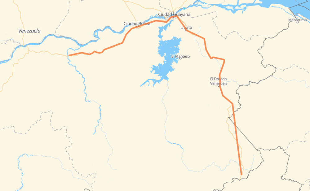
The distance from Santa Elena de Uairén to Maripa is 932 kilometers by road including 145 kilometers on motorways. Road takes approximately 11 hours and 12 minutes and goes through San Félix, Ciudad Guayana, Kilómetro 88, Las Claritas, El Dorado, El Callao and Mercado Municipal Chirica.
| Shortest distance by air | 549 km ✈️ |
| Car route length | 932 km 🚗 |
| Driving time | 11 h 12 min |
| Fuel amount | 74.6 L |
| Fuel cost | 132 AUD |
| Point | Distance | Time | Fuel | |
| 4.60745, -61.10369 | 0 km | 00 min | 0.0 L | |
|
T-10 55 km, 39 min
|
||||
| San Ignacio | 55 km | 39 min | 8.1 L | |
|
T-10 11 km, 08 min
|
||||
| San Francisco de Yuruaní | 66 km | 47 min | 8.9 L | |
|
T-10 241 km, 2 h 51 min
|
||||
| El Dorado | 307 km | 3 h 38 min | 18.3 L | |
|
T-10 276 km, 3 h 20 min
|
||||
| Mercado Municipal Chirica | 584 km | 6 h 59 min | 50.5 L | |
|
T-10 7 km, 05 min
|
||||
| San Félix | 590 km | 7 h 05 min | 51.1 L | |
|
7 km, 04 min
|
||||
| Ciudad Guayana | 597 km | 7 h 09 min | 51.6 L | |
|
T-19 7 km, 04 min
|
||||
| Cambalache | 604 km | 7 h 14 min | 52.0 L | |
|
T-19 98 km, 1 h 05 min
|
||||
| Guaricongo | 702 km | 8 h 19 min | 59.7 L | |
|
T-16 7 km, 04 min
|
||||
| Barrio 4 de febrero | 709 km | 8 h 24 min | 60.6 L | |
|
T-16 T-19 224 km, 2 h 47 min
|
||||
| Maripa | 932 km | 11 h 12 min | 68.1 L | |
Frequently Asked Questions
How much does it cost to drive from Santa Elena de Uairén to Maripa?
Fuel cost: 132 AUD
This fuel cost is calculated as: (Route length 932 km / 100 km) * (Fuel consumption 8 L/100 km) * (Fuel price 1.77 AUD / L)
You can adjust fuel consumption and fuel price here.
How long is a car ride from Santa Elena de Uairén to Maripa?
Driving time: 11 h 12 min
This time is calculated for driving at the maximum permitted speed, taking into account traffic rules restrictions.
- 37 km with a maximum speed 100 km/h = 22 min
- 289 km with a maximum speed 90 km/h = 3 h 12 min
- 597 km with a maximum speed 80 km/h = 7 h 27 min
- 6 km with a maximum speed 60 km/h = 5 min
- 2 km with a maximum speed 50 km/h = 1 min
- 1 km with a maximum speed 40 km/h = 1 min
The calculated driving time does not take into account intermediate stops and traffic jams.
How far is Santa Elena de Uairén to Maripa by land?
The distance between Santa Elena de Uairén and Maripa is 932 km by road including 145 km on motorways.
Precise satellite coordinates of highways were used for this calculation. The start and finish points are the centers of Santa Elena de Uairén and Maripa respectively.
How far is Santa Elena de Uairén to Maripa by plane?
The shortest distance (air line, as the crow flies) between Santa Elena de Uairén and Maripa is 549 km.
This distance is calculated using the Haversine formula as a great-circle distance between two points on the surface of a sphere. The start and finish points are the centers of Santa Elena de Uairén and Maripa respectively. Actual distance between airports may be different.
How many hours is Santa Elena de Uairén from Maripa by plane?
Boeing 737 airliner needs 41 min to cover the distance of 549 km at a cruising speed of 800 km/h.
Small plane "Cessna 172" needs 2 h 29 min to flight this distance at average speed of 220 km/h.
This time is approximate and do not take into account takeoff and landing times, airport location and other real world factors.
How long is a helicopter ride from Santa Elena de Uairén to Maripa?
Fast helicopter "Eurocopter AS350" or "Hughes OH-6 Cayuse" need 2 h 17 min to cover the distance of 549 km at a cruising speed of 240 km/h.
Popular "Robinson R44" needs 2 h 36 min to flight this distance at average speed of 210 km/h.
This time is approximate and do not take into account takeoff and landing times, aerodrome location and other real world factors.
What city is halfway between Santa Elena de Uairén and Maripa?
The halfway point between Santa Elena de Uairén and Maripa is Santa Maria de Upata. It is located about 15 km from the exact midpoint by road.
The distance from Santa Maria de Upata to Santa Elena de Uairén is 481 km and driving will take about 5 h 49 min. The road between Santa Maria de Upata and Maripa has length 451 km and will take approximately 5 h 23 min.
The other cities located close to halfway point:
Where is Santa Elena de Uairén in relation to Maripa?
Santa Elena de Uairén is located 549 km south-east of Maripa.
Santa Elena de Uairén has geographic coordinates: latitude 4.60745, longitude -61.10369.
Maripa has geographic coordinates: latitude 7.41721, longitude -65.18511.
Which highway goes from Santa Elena de Uairén to Maripa?
The route from Santa Elena de Uairén to Maripa follows T-10, T-19.
Other minor sections pass along the road:
- T-16: 7 km