Distance between Santa Helena and Martinho Campos
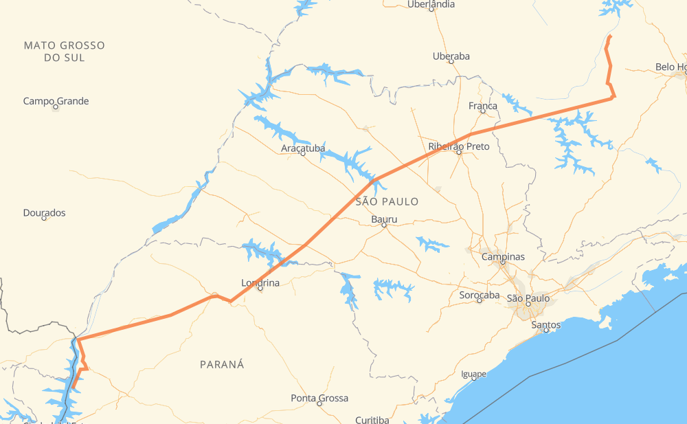
The distance from Santa Helena to Martinho Campos is 1,414 kilometers by road including 179 kilometers on motorways. Road takes approximately 16 hours and 11 minutes and goes through Assis, Tarumã, Parque das Oliveiras, Condomínio Balneário Recreativa, Itaú de Minas, Cancã and Piumhi.
| Shortest distance by air | 1,120 km ✈️ |
| Car route length | 1,414 km 🚗 |
| Driving time | 16 h 11 min |
| Fuel amount | 113.1 L |
| Fuel cost | 203.6 AUD |
| Point | Distance | Time | Fuel | |
| -24.85917, -54.33288 | 0 km | 00 min | 0.0 L | |
|
PR-323 572 km, 6 h 40 min
|
||||
| Tarumã | 572 km | 6 h 40 min | 90.9 L | |
|
SP-333 29 km, 21 min
|
||||
| Assis | 601 km | 7 h 01 min | 91.6 L | |
|
SP-333 331 km, 3 h 39 min
|
||||
| Parque das Oliveiras | 932 km | 10 h 40 min | 119.8 L | |
|
SP-328 5 km, 02 min
|
||||
| Condomínio Balneário Recreativa | 937 km | 10 h 43 min | 120.3 L | |
|
SP-330 BR-265 148 km, 1 h 37 min
|
||||
| Itaú de Minas | 1,085 km | 12 h 20 min | 131.7 L | |
|
MG-050 43 km, 29 min
|
||||
| Cancã | 1,128 km | 12 h 50 min | 135.4 L | |
|
MG-050 58 km, 39 min
|
||||
| Piumhi | 1,186 km | 13 h 30 min | 140.0 L | |
|
MG-050 56 km, 38 min
|
||||
| Córrego Fundo de Baixo | 1,242 km | 14 h 08 min | 144.6 L | |
|
MG-050 93 km, 1 h 04 min
|
||||
| Santo Antônio do Monte | 1,335 km | 15 h 13 min | 150.4 L | |
|
MG-164 79 km, 58 min
|
||||
| Martinho Campos | 1,414 km | 16 h 11 min | 158.3 L | |
Frequently Asked Questions
How much does it cost to drive from Santa Helena to Martinho Campos?
Fuel cost: 203.6 AUD
This fuel cost is calculated as: (Route length 1,414 km / 100 km) * (Fuel consumption 8 L/100 km) * (Fuel price 1.8 AUD / L)
You can adjust fuel consumption and fuel price here.
How long is a car ride from Santa Helena to Martinho Campos?
Driving time: 16 h 11 min
This time is calculated for driving at the maximum permitted speed, taking into account traffic rules restrictions.
- 118 km with a maximum speed 110 km/h = 1 h 4 min
- 15 km with a maximum speed 100 km/h = 8 min
- 990 km with a maximum speed 90 km/h = 10 h 59 min
- 241 km with a maximum speed 80 km/h = 3 h
- 8 km with a maximum speed 70 km/h = 6 min
- 24 km with a maximum speed 60 km/h = 24 min
- 1 km with a maximum speed 50 km/h = 1 min
- 17 km with a maximum speed 40 km/h = 25 min
The calculated driving time does not take into account intermediate stops and traffic jams.
How far is Santa Helena to Martinho Campos by land?
The distance between Santa Helena and Martinho Campos is 1,414 km by road including 179 km on motorways.
Precise satellite coordinates of highways were used for this calculation. The start and finish points are the centers of Santa Helena and Martinho Campos respectively.
How far is Santa Helena to Martinho Campos by plane?
The shortest distance (air line, as the crow flies) between Santa Helena and Martinho Campos is 1,120 km.
This distance is calculated using the Haversine formula as a great-circle distance between two points on the surface of a sphere. The start and finish points are the centers of Santa Helena and Martinho Campos respectively. Actual distance between airports may be different.
How many hours is Santa Helena from Martinho Campos by plane?
Boeing 737 airliner needs 1 h 24 min to cover the distance of 1,120 km at a cruising speed of 800 km/h.
Small plane "Cessna 172" needs 5 h 5 min to flight this distance at average speed of 220 km/h.
This time is approximate and do not take into account takeoff and landing times, airport location and other real world factors.
How long is a helicopter ride from Santa Helena to Martinho Campos?
Fast helicopter "Eurocopter AS350" or "Hughes OH-6 Cayuse" need 4 h 40 min to cover the distance of 1,120 km at a cruising speed of 240 km/h.
Popular "Robinson R44" needs 5 h 20 min to flight this distance at average speed of 210 km/h.
This time is approximate and do not take into account takeoff and landing times, aerodrome location and other real world factors.
What city is halfway between Santa Helena and Martinho Campos?
The halfway point between Santa Helena and Martinho Campos is Assis. It is located about 106 km from the exact midpoint by road.
The distance from Assis to Santa Helena is 601 km and driving will take about 7 h 1 min. The road between Assis and Martinho Campos has length 813 km and will take approximately 9 h 9 min.
The other cities located close to halfway point:
Where is Santa Helena in relation to Martinho Campos?
Santa Helena is located 1,120 km south-west of Martinho Campos.
Santa Helena has geographic coordinates: latitude -24.85917, longitude -54.33288.
Martinho Campos has geographic coordinates: latitude -19.33195, longitude -45.23667.
Which highway goes from Santa Helena to Martinho Campos?
The route from Santa Helena to Martinho Campos follows SP-333, PR-323, MG-050, MG-164.
Other minor sections pass along the road:
- BR-265: 74 km
- BR-272: 54 km
- BR-163: 52 km
- SP-351: 51 km
- PR-495: 40 km
- PR-444: 39 km
- SP-334: 29 km
- BR-376: 21 km
- PR-317: 15 km
- PR-445: 14 km
- SP-328: 13 km
- BR-369: 13 km
- PRC-467: 11 km
- BR-467: 11 km
- PR-986: 10 km
- SP-322: 9 km
- BR-153: 7 km
- MG-170: 3 km
- SP-270: 3 km
- BR-374: 3 km
- SP-330: 2 km
- BR-050: 2 km
- SPA 348/334: 1 km
- SP-294: 1 km