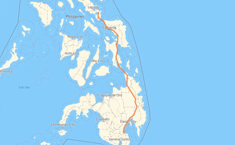
The distance from Santa Maria to Balogo is 1,034 kilometers by road. Road takes approximately 15 hours and 48 minutes and goes through Digos, Davao City, Bayugan, Surigao City, Tacloban, Catbalogan and Calbayog.
How much does it cost to drive from Santa Maria to Balogo?
Fuel cost:
147.2 AUD
This fuel cost is calculated as: (Route length 1,034 km / 100 km) * (Fuel consumption 8 L/100 km) * (Fuel price 1.78 AUD / L)
You can adjust fuel consumption and fuel price here.
How long is a car ride from Santa Maria to Balogo?
Driving time:
15 h 48 min
This time is calculated for driving at the maximum permitted speed, taking into account traffic rules restrictions.
140 km with a maximum speed 90 km/h = 1 h 33 min
613 km with a maximum speed 80 km/h = 7 h 39 min
5 km with a maximum speed 70 km/h = 3 min
177 km with a maximum speed 60 km/h = 2 h 56 min
50 km with a maximum speed 50 km/h = 59 min
8 km with a maximum speed 40 km/h = 11 min
3 km with a maximum speed 30 km/h = 5 min
46 km with a maximum speed 20 km/h = 2 h 18 min
The calculated driving time does not take into account intermediate stops and traffic jams.
How far is Santa Maria to Balogo by land?
The distance between Santa Maria and Balogo is 1,034 km by road.
Precise satellite coordinates of highways were used for this calculation. The start and finish points are the centers of Santa Maria and Balogo respectively.
How far is Santa Maria to Balogo by plane?
The shortest distance (air line, as the crow flies) between Santa Maria and Balogo is 732 km.
This distance is calculated using the Haversine formula as a great-circle distance between two points on the surface of a sphere. The start and finish points are the centers of Santa Maria and Balogo respectively. Actual distance between airports may be different.
How many hours is Santa Maria from Balogo by plane?
Boeing 737 airliner needs 54 min to cover the distance of 732 km at a cruising speed of 800 km/h.
Small plane "Cessna 172" needs 3 h 19 min to flight this distance at average speed of 220 km/h.
This time is approximate and do not take into account takeoff and landing times, airport location and other real world factors.
How long is a helicopter ride from Santa Maria to Balogo?
Fast helicopter "Eurocopter AS350" or "Hughes OH-6 Cayuse" need 3 h 3 min to cover the distance of 732 km at a cruising speed of 240 km/h.
Popular "Robinson R44" needs 3 h 29 min to flight this distance at average speed of 210 km/h.
This time is approximate and do not take into account takeoff and landing times, aerodrome location and other real world factors.
What city is halfway between Santa Maria and Balogo?
The halfway point between Santa Maria and Balogo is Benit.
The distance from Benit to Santa Maria is 517 km and driving will take about 7 h 50 min. The road between Benit and Balogo has length 517 km and will take approximately 7 h 58 min.
The other cities located close to halfway point:
San Ricardo is in 519 km from Santa Maria and 515 km from Balogo
Balong-balong is in 522 km from Santa Maria and 512 km from Balogo
Lobo is in 525 km from Santa Maria and 509 km from Balogo
Where is Santa Maria in relation to Balogo?
Santa Maria is located 732 km south of Balogo.
Santa Maria has geographic coordinates: latitude 6.55377, longitude 125.47429.
Balogo has geographic coordinates: latitude 12.97699, longitude 124.01974.
Which highway goes from Santa Maria to Balogo?
The route from Santa Maria to Balogo follows 1, AH26.