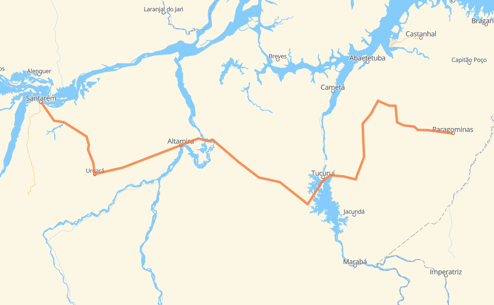
Distance between Santarém and Paragominas
The distance from Santarém to Paragominas is 1,228 kilometers by road. Road takes approximately 15 hours and 39 minutes and goes through Tailândia, Vila Residencial Belo Monte, Jacamin, Tipizal, Curuá-Una, Cicero Mendes and São Marcos.
| Shortest distance by air | 818 km ✈️ |
| Car route length | 1,228 km 🚗 |
| Driving time | 15 h 39 min |
| Fuel amount | 98.2 L |
| Fuel cost | 172.9 AUD |
| Point | Distance | Time | Fuel | |
| -2.43849, -54.69961 | 0 km | 00 min | 0.0 L | |
|
PA-370 19 km, 13 min
|
||||
| Jacamin | 19 km | 13 min | 2.1 L | |
|
PA-370 82 km, 1 h 16 min
|
||||
| Curuá-Una | 102 km | 1 h 30 min | 6.6 L | |
|
PA-370 145 km, 2 h 01 min
|
||||
| São Marcos | 247 km | 3 h 31 min | 19.9 L | |
|
BR-230 120 km, 1 h 21 min
|
||||
| Carlos Pena Filho | 367 km | 4 h 52 min | 30.2 L | |
|
BR-230 16 km, 11 min
|
||||
| Agrovila União | 382 km | 5 h 04 min | 30.6 L | |
|
BR-230 76 km, 51 min
|
||||
| Santo Antônio | 458 km | 5 h 55 min | 37.6 L | |
|
BR-230 6 km, 04 min
|
||||
| Vila Residencial Belo Monte | 464 km | 6 h 00 min | 37.9 L | |
|
BR-230 8 km, 06 min
|
||||
| Belo Monte do Pontal | 472 km | 6 h 07 min | 38.6 L | |
|
BR-230 464 km, 5 h 39 min
|
||||
| Tailândia | 936 km | 11 h 46 min | 73.1 L | |
|
PA-150 PA-256 292 km, 3 h 52 min
|
||||
| Paragominas | 1,228 km | 15 h 39 min | 98.9 L | |
Hotels of Paragominas
Frequently Asked Questions
How much does it cost to drive from Santarém to Paragominas?
Fuel cost: 172.9 AUD
This fuel cost is calculated as: (Route length 1,228 km / 100 km) * (Fuel consumption 8 L/100 km) * (Fuel price 1.76 AUD / L)
You can adjust fuel consumption and fuel price here.
How long is a car ride from Santarém to Paragominas?
Driving time: 15 h 39 min
This time is calculated for driving at the maximum permitted speed, taking into account traffic rules restrictions.
- 554 km with a maximum speed 90 km/h = 6 h 9 min
- 537 km with a maximum speed 80 km/h = 6 h 43 min
- 9 km with a maximum speed 60 km/h = 8 min
- 112 km with a maximum speed 50 km/h = 2 h 13 min
- 15 km with a maximum speed 40 km/h = 22 min
- 1 km with a maximum speed 20 km/h = 2 min
The calculated driving time does not take into account intermediate stops and traffic jams.
How far is Santarém to Paragominas by land?
The distance between Santarém and Paragominas is 1,228 km by road.
Precise satellite coordinates of highways were used for this calculation. The start and finish points are the centers of Santarém and Paragominas respectively.
How far is Santarém to Paragominas by plane?
The shortest distance (air line, as the crow flies) between Santarém and Paragominas is 818 km.
This distance is calculated using the Haversine formula as a great-circle distance between two points on the surface of a sphere. The start and finish points are the centers of Santarém and Paragominas respectively. Actual distance between airports may be different.
How many hours is Santarém from Paragominas by plane?
Boeing 737 airliner needs 1 h 1 min to cover the distance of 818 km at a cruising speed of 800 km/h.
Small plane "Cessna 172" needs 3 h 43 min to flight this distance at average speed of 220 km/h.
This time is approximate and do not take into account takeoff and landing times, airport location and other real world factors.
How long is a helicopter ride from Santarém to Paragominas?
Fast helicopter "Eurocopter AS350" or "Hughes OH-6 Cayuse" need 3 h 24 min to cover the distance of 818 km at a cruising speed of 240 km/h.
Popular "Robinson R44" needs 3 h 53 min to flight this distance at average speed of 210 km/h.
This time is approximate and do not take into account takeoff and landing times, aerodrome location and other real world factors.
What city is halfway between Santarém and Paragominas?
The halfway point between Santarém and Paragominas is Aratau. It is located about 21 km from the exact midpoint by road.
The distance from Aratau to Santarém is 635 km and driving will take about 8 h 3 min. The road between Aratau and Paragominas has length 592 km and will take approximately 7 h 36 min.
The other cities located close to halfway point:
Where is Santarém in relation to Paragominas?
Santarém is located 818 km west of Paragominas.
Santarém has geographic coordinates: latitude -2.43849, longitude -54.69961.
Paragominas has geographic coordinates: latitude -2.99564, longitude -47.35489.
Which highway goes from Santarém to Paragominas?
The route from Santarém to Paragominas follows BR-230, PA-370, PA-256, PA-150, PA-475.
Other minor sections pass along the road:
- PA-263: 73 km
- BR-422: 60 km