Distance between Santiago Tuxtla and Papantla de Olarte
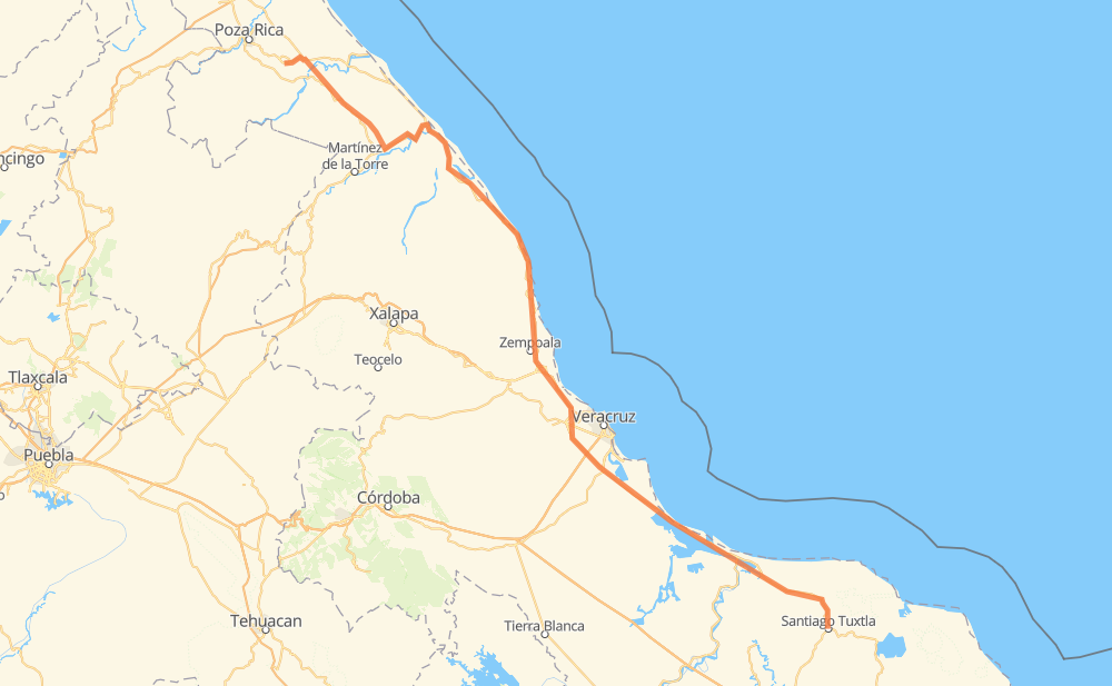
The distance from Santiago Tuxtla to Papantla de Olarte is 373 kilometers by road including 19 kilometers on motorways. Road takes approximately 4 hours and 28 minutes and goes through Ángel R. Cabada, Alvarado, José Cardel, Tapalapan, Tecolapan, Tula and La Laguna y Monte del Castillo.
| Shortest distance by air | 306 km ✈️ |
| Car route length | 373 km 🚗 |
| Driving time | 4 h 28 min |
| Fuel amount | 29.8 L |
| Fuel cost | 52.5 AUD |
| Toll roads cost | 207 + ? MXN |
| Point | Distance | Time | Fuel | |
| Santiago Tuxtla | 0 km | 00 min | 0.0 L | |
|
14 km, 10 min
|
||||
| Tecolapan | 14 km | 10 min | 0.0 L | |
|
MEX 180 18 km, 13 min
|
||||
| Ángel R. Cabada | 33 km | 24 min | 2.2 L | |
|
MEX 180 46 km, 34 min
|
||||
| Alvarado | 79 km | 59 min | 4.4 L | |
|
MEX 180 57 km, 41 min
|
||||
| Santa Rita | 136 km | 1 h 40 min | 10.3 L | |
|
MEX 180 10 km, 06 min
|
||||
| Delfino Victoria - Santa Fe | 146 km | 1 h 47 min | 11.5 L | |
|
MEX 180 9 km, 05 min
|
||||
| San Julián | 155 km | 1 h 53 min | 12.0 L | |
|
MEX 180D 10 km, 05 min
|
||||
| Nicolás Blanco (San Pancho) | 165 km | 1 h 58 min | 12.9 L | |
|
MEX 180D 5 km, 03 min
|
||||
| José Cardel | 170 km | 2 h 01 min | 13.5 L | |
|
MEX 180 203 km, 2 h 26 min
|
||||
| Papantla de Olarte | 373 km | 4 h 28 min | 29.6 L | |
Hotels of Papantla de Olarte
Frequently Asked Questions
How many toll booths are there from Santiago Tuxtla to Papantla de Olarte?
There are 5 toll booths between Santiago Tuxtla and Papantla de Olarte: Cardel - Posa Rica, Nautla, La Antigua, San Julián and Alvarado.
How much does the toll booths cost from Santiago Tuxtla to Papantla de Olarte?
Toll roads cost: Alvarado (24 MXN) + San Julián (?) + La Antigua (?) + Nautla (24 MXN) + Cardel - Posa Rica (159 MXN) = 207 + ? MXN
How much does it cost to drive from Santiago Tuxtla to Papantla de Olarte?
Fuel cost: 52.5 AUD
This fuel cost is calculated as: (Route length 373 km / 100 km) * (Fuel consumption 8 L/100 km) * (Fuel price 1.76 AUD / L)
You can adjust fuel consumption and fuel price here.
Toll roads cost: 207 + ? MXN
How long is a car ride from Santiago Tuxtla to Papantla de Olarte?
Driving time: 4 h 28 min
This time is calculated for driving at the maximum permitted speed, taking into account traffic rules restrictions.
- 19 km with a maximum speed 110 km/h = 10 min
- 99 km with a maximum speed 90 km/h = 1 h 6 min
- 253 km with a maximum speed 80 km/h = 3 h 9 min
The calculated driving time does not take into account intermediate stops and traffic jams.
How far is Santiago Tuxtla to Papantla de Olarte by land?
The distance between Santiago Tuxtla and Papantla de Olarte is 373 km by road including 19 km on motorways.
Precise satellite coordinates of highways were used for this calculation. The start and finish points are the centers of Santiago Tuxtla and Papantla de Olarte respectively.
How far is Santiago Tuxtla to Papantla de Olarte by plane?
The shortest distance (air line, as the crow flies) between Santiago Tuxtla and Papantla de Olarte is 306 km.
This distance is calculated using the Haversine formula as a great-circle distance between two points on the surface of a sphere. The start and finish points are the centers of Santiago Tuxtla and Papantla de Olarte respectively. Actual distance between airports may be different.
How many hours is Santiago Tuxtla from Papantla de Olarte by plane?
Boeing 737 airliner needs 22 min to cover the distance of 306 km at a cruising speed of 800 km/h.
Small plane "Cessna 172" needs 1 h 23 min to flight this distance at average speed of 220 km/h.
This time is approximate and do not take into account takeoff and landing times, airport location and other real world factors.
How long is a helicopter ride from Santiago Tuxtla to Papantla de Olarte?
Fast helicopter "Eurocopter AS350" or "Hughes OH-6 Cayuse" need 1 h 16 min to cover the distance of 306 km at a cruising speed of 240 km/h.
Popular "Robinson R44" needs 1 h 27 min to flight this distance at average speed of 210 km/h.
This time is approximate and do not take into account takeoff and landing times, aerodrome location and other real world factors.
What city is halfway between Santiago Tuxtla and Papantla de Olarte?
The halfway point between Santiago Tuxtla and Papantla de Olarte is Paso del Cedro. It is located about 1 km from the exact midpoint by road.
The distance from Paso del Cedro to Santiago Tuxtla is 187 km and driving will take about 2 h 14 min. The road between Paso del Cedro and Papantla de Olarte has length 186 km and will take approximately 2 h 13 min.
The other cities located close to halfway point:
Where is Santiago Tuxtla in relation to Papantla de Olarte?
Santiago Tuxtla is located 306 km south-east of Papantla de Olarte.
Santiago Tuxtla has geographic coordinates: latitude 18.4654, longitude -95.30241.
Papantla de Olarte has geographic coordinates: latitude 20.44673, longitude -97.32285.
Which highway goes from Santiago Tuxtla to Papantla de Olarte?
The route from Santiago Tuxtla to Papantla de Olarte follows MEX 180.
Other minor sections pass along the road:
- MEX 180D: 66 km
- MEX 129: 23 km