Distance between Satna and Lalbhitti
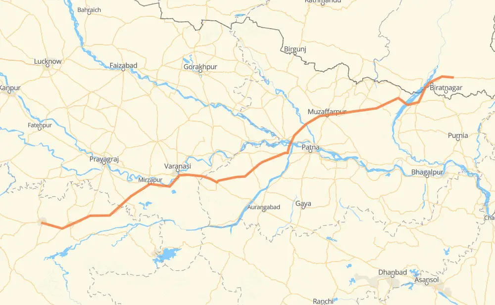
The distance from Satna to Lalbhitti is 814 kilometers by road. Road takes approximately 9 hours and 33 minutes and goes through Rewa, Varanasi, Arrah, Muzaffarpur and Darbhanga.
| Shortest distance by air | 699 km ✈️ |
| Car route length | 814 km 🚗 |
| Driving time | 9 h 33 min |
| Fuel amount | 65.1 L |
| Fuel cost | 115.9 AUD |
| Point | Distance | Time | Fuel | |
| Satna | 0 km | 00 min | 0.0 L | |
|
NH39 50 km, 34 min
|
||||
| Rewa | 50 km | 34 min | 3.5 L | |
|
NH39 NH135 200 km, 2 h 18 min
|
||||
| Chunar | 250 km | 2 h 53 min | 19.7 L | |
|
NH35 32 km, 23 min
|
||||
| Mughal Sarai | 281 km | 3 h 16 min | 22.2 L | |
|
NH19 15 km, 10 min
|
||||
| Chandauli | 296 km | 3 h 27 min | 23.3 L | |
|
NH19 42 km, 31 min
|
||||
| Mohania | 338 km | 3 h 59 min | 26.8 L | |
|
NH319 118 km, 1 h 20 min
|
||||
| Arrah | 456 km | 5 h 19 min | 36.1 L | |
|
NH922 NH722 103 km, 1 h 13 min
|
||||
| Muzaffarpur | 559 km | 6 h 32 min | 44.4 L | |
|
NH722 NH27 63 km, 44 min
|
||||
| Darbhanga | 622 km | 7 h 17 min | 49.3 L | |
|
NH27 191 km, 2 h 15 min
|
||||
| Lalbhitti | 814 km | 9 h 33 min | 64.4 L | |
Frequently Asked Questions
How much does it cost to drive from Satna to Lalbhitti?
Fuel cost: 115.9 AUD
This fuel cost is calculated as: (Route length 814 km / 100 km) * (Fuel consumption 8 L/100 km) * (Fuel price 1.78 AUD / L)
You can adjust fuel consumption and fuel price here.
How long is a car ride from Satna to Lalbhitti?
Driving time: 9 h 33 min
This time is calculated for driving at the maximum permitted speed, taking into account traffic rules restrictions.
- 458 km with a maximum speed 90 km/h = 5 h 5 min
- 353 km with a maximum speed 80 km/h = 4 h 24 min
- 3 km with a maximum speed 50 km/h = 3 min
The calculated driving time does not take into account intermediate stops and traffic jams.
How far is Satna to Lalbhitti by land?
The distance between Satna and Lalbhitti is 814 km by road.
Precise satellite coordinates of highways were used for this calculation. The start and finish points are the centers of Satna and Lalbhitti respectively.
How far is Satna to Lalbhitti by plane?
The shortest distance (air line, as the crow flies) between Satna and Lalbhitti is 699 km.
This distance is calculated using the Haversine formula as a great-circle distance between two points on the surface of a sphere. The start and finish points are the centers of Satna and Lalbhitti respectively. Actual distance between airports may be different.
How many hours is Satna from Lalbhitti by plane?
Boeing 737 airliner needs 52 min to cover the distance of 699 km at a cruising speed of 800 km/h.
Small plane "Cessna 172" needs 3 h 10 min to flight this distance at average speed of 220 km/h.
This time is approximate and do not take into account takeoff and landing times, airport location and other real world factors.
How long is a helicopter ride from Satna to Lalbhitti?
Fast helicopter "Eurocopter AS350" or "Hughes OH-6 Cayuse" need 2 h 54 min to cover the distance of 699 km at a cruising speed of 240 km/h.
Popular "Robinson R44" needs 3 h 19 min to flight this distance at average speed of 210 km/h.
This time is approximate and do not take into account takeoff and landing times, aerodrome location and other real world factors.
What city is halfway between Satna and Lalbhitti?
The halfway point between Satna and Lalbhitti is Dinara. It is located about 31 km from the exact midpoint by road.
The distance from Dinara to Satna is 376 km and driving will take about 4 h 24 min. The road between Dinara and Lalbhitti has length 438 km and will take approximately 5 h 8 min.
The other cities located close to halfway point:
Where is Satna in relation to Lalbhitti?
Satna is located 699 km south-west of Lalbhitti.
Satna has geographic coordinates: latitude 24.57513, longitude 80.83257.
Lalbhitti has geographic coordinates: latitude 26.66251, longitude 87.40569.
Which highway goes from Satna to Lalbhitti?
The route from Satna to Lalbhitti follows NH27, NH135, NH319.
Other minor sections pass along the road:
- NH19: 63 km
- NH722: 63 km
- NH35: 60 km
- H01: 53 km
- NH39: 34 km
- NH30: 30 km
- NH131: 27 km
- MDR: 18 km
- NH922: 13 km
- NH22: 6 km
- SH24: 3 km