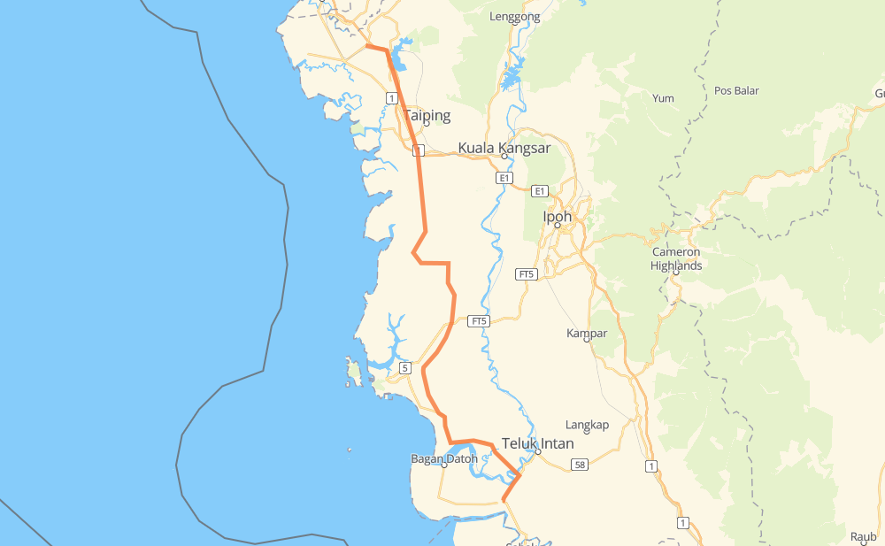
Distance between Simpang Empat and Alor Pongsu
The distance from Simpang Empat to Alor Pongsu is 178 kilometers by road including 88 kilometers on motorways. Road takes approximately 1 hour and 53 minutes and goes through Changkat Jering, Bagan Serai, Kampong Kayan, Beruas, Sungai Rotan and Kampung Dew.
| Shortest distance by air | 134 km ✈️ |
| Car route length | 178 km 🚗 |
| Driving time | 1 h 53 min |
| Fuel amount | 14.2 L |
| Fuel cost | 25.6 AUD |
| Point | Distance | Time | Fuel | |
| Simpang Empat | 0 km | 00 min | 0.0 L | |
|
5 33 km, 22 min
|
||||
| Kampong Kayan | 33 km | 22 min | 2.5 L | |
|
5 E32 63 km, 39 min
|
||||
| Beruas | 96 km | 1 h 02 min | 7.2 L | |
|
73 60 11 km, 07 min
|
||||
| Sungai Rotan | 107 km | 1 h 09 min | 8.3 L | |
|
60 3 km, 02 min
|
||||
| Durian Sebatang | 110 km | 1 h 12 min | 8.7 L | |
|
60 28 km, 18 min
|
||||
| Changkat Jering | 138 km | 1 h 30 min | 10.7 L | |
|
E1 18 km, 10 min
|
||||
| Kampung Dew | 156 km | 1 h 40 min | 12.1 L | |
|
E1 22 km, 12 min
|
||||
| Alor Pongsu | 178 km | 1 h 53 min | 13.5 L | |
Frequently Asked Questions
How much does it cost to drive from Simpang Empat to Alor Pongsu?
Fuel cost: 25.6 AUD
This fuel cost is calculated as: (Route length 178 km / 100 km) * (Fuel consumption 8 L/100 km) * (Fuel price 1.8 AUD / L)
You can adjust fuel consumption and fuel price here.
How long is a car ride from Simpang Empat to Alor Pongsu?
Driving time: 1 h 53 min
This time is calculated for driving at the maximum permitted speed, taking into account traffic rules restrictions.
- 38 km with a maximum speed 110 km/h = 20 min
- 47 km with a maximum speed 100 km/h = 28 min
- 61 km with a maximum speed 90 km/h = 40 min
- 31 km with a maximum speed 80 km/h = 23 min
The calculated driving time does not take into account intermediate stops and traffic jams.
How far is Simpang Empat to Alor Pongsu by land?
The distance between Simpang Empat and Alor Pongsu is 178 km by road including 88 km on motorways.
Precise satellite coordinates of highways were used for this calculation. The start and finish points are the centers of Simpang Empat and Alor Pongsu respectively.
How far is Simpang Empat to Alor Pongsu by plane?
The shortest distance (air line, as the crow flies) between Simpang Empat and Alor Pongsu is 134 km.
This distance is calculated using the Haversine formula as a great-circle distance between two points on the surface of a sphere. The start and finish points are the centers of Simpang Empat and Alor Pongsu respectively. Actual distance between airports may be different.
How many hours is Simpang Empat from Alor Pongsu by plane?
Boeing 737 airliner needs 10 min to cover the distance of 134 km at a cruising speed of 800 km/h.
Small plane "Cessna 172" needs 36 min to flight this distance at average speed of 220 km/h.
This time is approximate and do not take into account takeoff and landing times, airport location and other real world factors.
How long is a helicopter ride from Simpang Empat to Alor Pongsu?
Fast helicopter "Eurocopter AS350" or "Hughes OH-6 Cayuse" need 33 min to cover the distance of 134 km at a cruising speed of 240 km/h.
Popular "Robinson R44" needs 38 min to flight this distance at average speed of 210 km/h.
This time is approximate and do not take into account takeoff and landing times, aerodrome location and other real world factors.
What city is halfway between Simpang Empat and Alor Pongsu?
The halfway point between Simpang Empat and Alor Pongsu is Beruas. It is located about 7 km from the exact midpoint by road.
The distance from Beruas to Simpang Empat is 96 km and driving will take about 1 h 2 min. The road between Beruas and Alor Pongsu has length 82 km and will take approximately 51 min.
The other cities located close to halfway point:
Where is Simpang Empat in relation to Alor Pongsu?
Simpang Empat is located 134 km south-east of Alor Pongsu.
Simpang Empat has geographic coordinates: latitude 3.90065, longitude 100.93696.
Alor Pongsu has geographic coordinates: latitude 5.05248, longitude 100.58867.