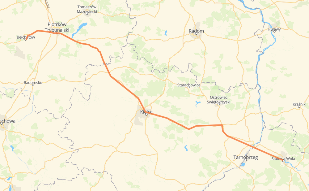
Distance between Stalowa Wola and Belchatow

The distance from Stalowa Wola to Belchatow is 244 kilometers by road. Road takes approximately 3 hours and 33 minutes and goes through Petrikau, Sandomir, Opatów, Łazy and Podklasztorze.

Click here to load the interactive map
Compare this route in other services:
City
Town
Village
Hamlet
Motorway
Primary
Secondary
Unclassified
Point Distance Time Fuel
Stalowa Wola 0 km 0:00 00 min 0.0 L
77 8 km, 06 min
Agatówka 8 km 0:06 06 min 0.6 L
77 23 km, 22 min
Sandomir 31 km 0:29 29 min 2.2 L
77 5 km, 06 min
Milczany 36 km 0:35 35 min 2.8 L
77 10 km, 07 min
Kleczanów 45 km 0:42 42 min 3.6 L
77 9 16 km, 13 min
Opatów 62 km 0:56 56 min 4.8 L
74 64 km, 55 min
Łazy 126 km 1:52 1 h 52 min 10.0 L
74 79 km, 1 h 06 min
Podklasztorze 205 km 2:58 2 h 58 min 16.3 L
12 14 km, 12 min
Petrikau 218 km 3:11 3 h 11 min 17.2 L
473 74 26 km, 21 min
Belchatow 244 km 3:32 3 h 32 min 19.3 L
City
Town
Village
Hamlet
Motorway
Primary
Secondary
Unclassified
Point Distance Time Fuel
Stalowa Wola 0 km 0:00 00 min 0.0 L
77 8 km, 06 min
Agatówka 8 km 0:06 06 min 0.6 L
77 5 km, 05 min
Okręglica 13 km 0:11 11 min 1.0 L
77 1 km, 00 min
Stara Wieś 14 km 0:12 12 min 1.1 L
77 1 km, 00 min
Łęki 15 km 0:13 13 min 1.1 L
77 1 km, 00 min
Ruski Bród 15 km 0:14 14 min 1.2 L
77 6 km, 04 min
Ług 21 km 0:18 18 min 1.6 L
77 1 km, 01 min
Podkole 22 km 0:20 20 min 1.7 L
77 4 km, 03 min
Piekło 26 km 0:23 23 min 2.0 L
77 5 km, 05 min
Sandomir 31 km 0:28 28 min 2.2 L
77 5 km, 06 min
Milczany 36 km 0:35 35 min 2.8 L
77 3 km, 02 min
Łupicha 38 km 0:37 37 min 3.0 L
77 2 km, 01 min
Domki 40 km 0:38 38 min 3.1 L
77 3 km, 02 min
Przyłogi 43 km 0:40 40 min 3.3 L
77 2 km, 01 min
Kleczanów 45 km 0:42 42 min 3.6 L
77 3 km, 02 min
Gołębiów 49 km 0:44 44 min 3.9 L
77 3 km, 02 min
Krzyże 51 km 0:47 47 min 4.1 L
9 2 km, 01 min
Pęcławice 53 km 0:48 48 min 4.1 L
9 2 km, 01 min
Włostów 55 km 0:49 49 min 4.3 L
9 5 km, 03 min
Oficjałów 59 km 0:53 53 min 4.7 L
9 2 km, 02 min
Opatów 62 km 0:56 56 min 4.8 L
74 2 km, 01 min
Przy Szosie 64 km 0:57 57 min 5.1 L
74 4 km, 02 min
Gołoszyce Niższe 67 km 1:00 1 h 00 min 5.1 L
74 5 km, 03 min
Gołoszyce 72 km 1:03 1 h 03 min 5.7 L
74 2 km, 01 min
Baćkowice 74 km 1:05 1 h 05 min 5.8 L
74 2 km, 01 min
Poddane 76 km 1:06 1 h 06 min 6.1 L
74 3 km, 01 min
Nieskurzów Nowy 79 km 1:08 1 h 08 min 6.2 L
74 3 km, 02 min
Piórków-Kolonia 82 km 1:10 1 h 10 min 6.5 L
74 1 km, 01 min
Piotrów-Zagościniec 83 km 1:12 1 h 12 min 6.6 L
74 5 km, 05 min
Złota Woda 89 km 1:17 1 h 17 min 7.0 L
74 3 km, 01 min
Lechówek 92 km 1:19 1 h 19 min 7.2 L
74 2 km, 01 min
Lechów 94 km 1:20 1 h 20 min 7.4 L
74 1 km, 01 min
Podół 95 km 1:22 1 h 22 min 7.6 L
74 0 km, 00 min
Padole 95 km 1:22 1 h 22 min 7.6 L
74 1 km, 00 min
Makoszyn 96 km 1:23 1 h 23 min 7.6 L
74 2 km, 02 min
Belno 99 km 1:26 1 h 26 min 7.8 L
74 2 km, 01 min
Podbelnie 100 km 1:27 1 h 27 min 8.0 L
74 1 km, 01 min
Napęków 102 km 1:28 1 h 28 min 8.1 L
74 2 km, 01 min
Skorzeszyce 104 km 1:30 1 h 30 min 8.2 L
74 3 km, 02 min
Rudki 106 km 1:32 1 h 32 min 8.4 L
74 2 km, 01 min
Rzechty 108 km 1:33 1 h 33 min 8.5 L
74 2 km, 01 min
Bór 109 km 1:35 1 h 35 min 8.7 L
74 3 km, 03 min
Radlin 113 km 1:39 1 h 39 min 8.8 L
74 4 km, 04 min
Cedzyna 117 km 1:43 1 h 43 min 9.2 L
S74 2 km, 01 min
Stara Wieś 119 km 1:45 1 h 45 min 9.5 L
S74 74 6 km, 06 min
Łazy 126 km 1:51 1 h 51 min 10.0 L
74 3 km, 02 min
Pod Olszynami 128 km 1:54 1 h 54 min 10.2 L
74 3 km, 03 min
Miedziana Góra 131 km 1:57 1 h 57 min 10.4 L
74 3 km, 02 min
Wykień 134 km 2:00 2 h 00 min 10.7 L
74 1 km, 00 min
Wyrowce 135 km 2:00 2 h 00 min 10.8 L
74 1 km, 00 min
Podgród 135 km 2:01 2 h 01 min 10.8 L
74 1 km, 00 min
Ćmińsk 136 km 2:02 2 h 02 min 10.9 L
74 1 km, 00 min
Podglinie 137 km 2:03 2 h 03 min 10.9 L
74 2 km, 01 min
Berlinka 139 km 2:04 2 h 04 min 11.0 L
74 1 km, 01 min
Raszówka 140 km 2:05 2 h 05 min 11.2 L
74 1 km, 00 min
Pogłodów 141 km 2:06 2 h 06 min 11.3 L
74 1 km, 00 min
Sewerynówka 142 km 2:06 2 h 06 min 11.3 L
74 1 km, 00 min
Stary Mniów 142 km 2:07 2 h 07 min 11.4 L
74 0 km, 00 min
Mniów 142 km 2:07 2 h 07 min 11.4 L
74 2 km, 01 min
Olszyna 144 km 2:09 2 h 09 min 11.5 L
74 3 km, 01 min
Zastawie 147 km 2:11 2 h 11 min 11.7 L
74 2 km, 01 min
Podsmyków 149 km 2:12 2 h 12 min 11.8 L
74 3 km, 02 min
Rozgół 153 km 2:15 2 h 15 min 12.1 L
74 9 km, 06 min
Jacentów 162 km 2:21 2 h 21 min 12.7 L
74 13 km, 08 min
Grębenice 175 km 2:30 2 h 30 min 13.9 L
74 4 km, 03 min
Żarnów 178 km 2:33 2 h 33 min 14.2 L
74 1 km, 01 min
Trojanowice 180 km 2:35 2 h 35 min 14.3 L
74 2 km, 01 min
Odrowąż 181 km 2:36 2 h 36 min 14.5 L
74 0 km, 00 min
Zalesie 182 km 2:37 2 h 37 min 14.5 L
74 1 km, 01 min
Solec 183 km 2:38 2 h 38 min 14.6 L
74 2 km, 02 min
Dąbrówka 185 km 2:40 2 h 40 min 14.8 L
74 2 km, 02 min
Kłopotów 188 km 2:42 2 h 42 min 15.0 L
74 2 km, 01 min
Krasik 190 km 2:44 2 h 44 min 15.1 L
74 3 km, 02 min
Wójcin B 193 km 2:47 2 h 47 min 15.4 L
74 4 km, 02 min
Honoratów 196 km 2:49 2 h 49 min 15.6 L
74 2 km, 01 min
Jaksonek 198 km 2:51 2 h 51 min 15.7 L
74 7 km, 06 min
Podklasztorze 205 km 2:57 2 h 57 min 16.3 L
12 2 km, 01 min
Polanka 207 km 2:59 2 h 59 min 16.5 L
12 1 km, 01 min
Włodzimierzów 208 km 3:00 3 h 00 min 16.6 L
12 1 km, 01 min
Przygłów 209 km 3:01 3 h 01 min 16.7 L
12 2 km, 01 min
Korytnica 211 km 3:02 3 h 02 min 16.8 L
12 2 km, 01 min
Poniatów 213 km 3:04 3 h 04 min 17.0 L
12 5 km, 05 min
Petrikau 218 km 3:09 3 h 09 min 17.2 L
473 74 8 km, 07 min
Dąbrówka 226 km 3:17 3 h 17 min 18.0 L
74 1 km, 01 min
Gomulin-Kolonia 227 km 3:18 3 h 18 min 18.1 L
74 2 km, 01 min
Żachta 229 km 3:20 3 h 20 min 18.3 L
74 3 km, 01 min
Budków 232 km 3:22 3 h 22 min 18.5 L
74 4 km, 02 min
Huta 236 km 3:25 3 h 25 min 18.6 L
74 3 km, 02 min
Kanada 240 km 3:27 3 h 27 min 19.2 L
476 5 km, 04 min
Belchatow 244 km 3:31 3 h 31 min 19.3 L

Frequently Asked Questions

How much does it cost to drive from Stalowa Wola to Belchatow?

Fuel cost: 35 AUD

This fuel cost is calculated as: (Route length 244 km / 100 km) * (Fuel consumption 8 L/100 km) * (Fuel price 1.79 AUD / L)

You can adjust fuel consumption and fuel price here.

How long is a car ride from Stalowa Wola to Belchatow?

Driving time: 3 h 33 min

This time is calculated for driving at the maximum permitted speed, taking into account traffic rules restrictions.

  • 127 km with a maximum speed 90 km/h = 1 h 24 min
  • 14 km with a maximum speed 80 km/h = 10 min
  • 23 km with a maximum speed 70 km/h = 19 min
  • 77 km with a maximum speed 50 km/h = 1 h 32 min
  • 3 km with a maximum speed 40 km/h = 4 min

The calculated driving time does not take into account intermediate stops and traffic jams.

How far is Stalowa Wola to Belchatow by land?

The distance between Stalowa Wola and Belchatow is 244 km by road.

Precise satellite coordinates of highways were used for this calculation. The start and finish points are the centers of Stalowa Wola and Belchatow respectively.

How far is Stalowa Wola to Belchatow by plane?

The shortest distance (air line, as the crow flies) between Stalowa Wola and Belchatow is 209 km.

This distance is calculated using the Haversine formula as a great-circle distance between two points on the surface of a sphere. The start and finish points are the centers of Stalowa Wola and Belchatow respectively. Actual distance between airports may be different.

How many hours is Stalowa Wola from Belchatow by plane?

Boeing 737 airliner needs 15 min to cover the distance of 209 km at a cruising speed of 800 km/h.

Small plane "Cessna 172" needs 57 min to flight this distance at average speed of 220 km/h.

This time is approximate and do not take into account takeoff and landing times, airport location and other real world factors.

How long is a helicopter ride from Stalowa Wola to Belchatow?

Fast helicopter "Eurocopter AS350" or "Hughes OH-6 Cayuse" need 52 min to cover the distance of 209 km at a cruising speed of 240 km/h.

Popular "Robinson R44" needs 59 min to flight this distance at average speed of 210 km/h.

This time is approximate and do not take into account takeoff and landing times, aerodrome location and other real world factors.

What city is halfway between Stalowa Wola and Belchatow?

The halfway point between Stalowa Wola and Belchatow is Stara Wieś. It is located about 3 km from the exact midpoint by road.

The distance from Stara Wieś to Stalowa Wola is 119 km and driving will take about 1 h 45 min. The road between Stara Wieś and Belchatow has length 125 km and will take approximately 1 h 47 min.

The other cities located close to halfway point:

  • Łazy is in 126 km from Stalowa Wola and 119 km from Belchatow
  • Cedzyna is in 117 km from Stalowa Wola and 127 km from Belchatow
  • Pod Olszynami is in 128 km from Stalowa Wola and 116 km from Belchatow

Where is Stalowa Wola in relation to Belchatow?

Stalowa Wola is located 209 km south-east of Belchatow.

Stalowa Wola has geographic coordinates: latitude 50.56901, longitude 22.06447.

Belchatow has geographic coordinates: latitude 51.36504, longitude 19.3684.

Which highway goes from Stalowa Wola to Belchatow?

The route from Stalowa Wola to Belchatow follows 74.

Other minor sections pass along the road:

  • 77: 46 km
  • 12: 12 km
  • 9: 12 km
  • S74: 6 km
  • 476: 3 km
  • 473: 2 km
  • 79: 1 km
The distance between Stalowa Wola and Belchatow is ranked 6,817th in the ranking popularity.
Have any questions? Contact us!