Distance between Tahdziú and Ciudad Guzmán
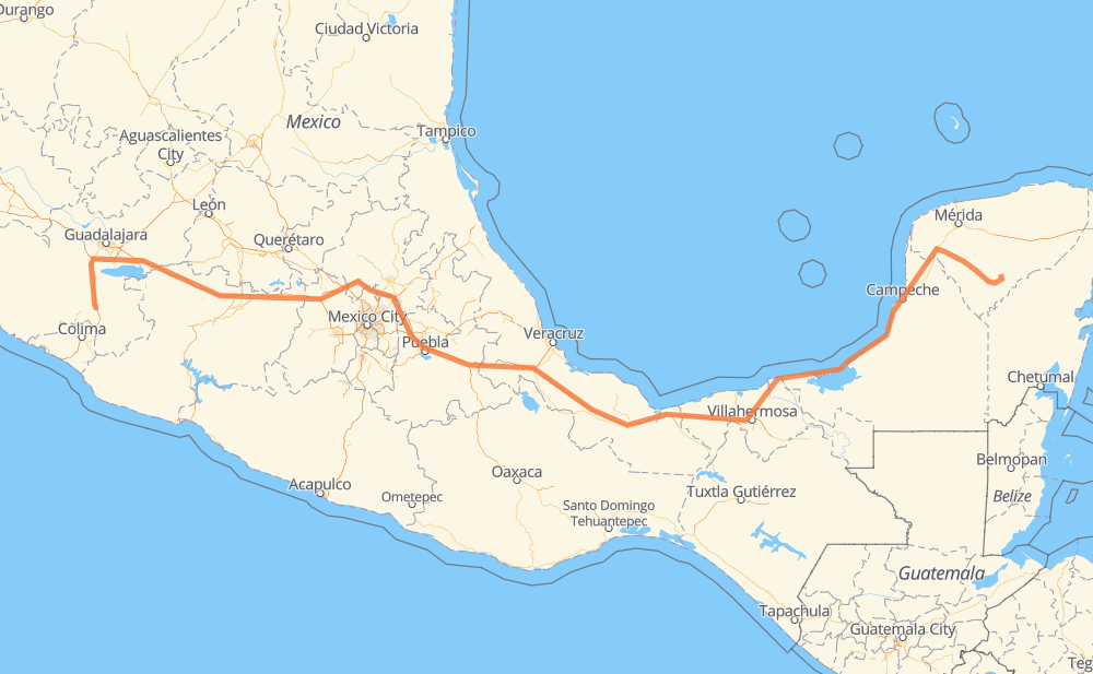
The distance from Tahdziú to Ciudad Guzmán is 2,041 kilometers by road including 1,313 kilometers on motorways. Road takes approximately 22 hours and 39 minutes and goes through Orizaba, Peto, Tzucacab, Tekax de Álvaro Obregón, Akil, Oxkutzcab and Ticul.
| Shortest distance by air | 1,518 km ✈️ |
| Car route length | 2,041 km 🚗 |
| Driving time | 22 h 39 min |
| Fuel amount | 163.3 L |
| Fuel cost | 293.9 AUD |
| Toll roads cost | 1,495 + ? MXN |
| Point | Distance | Time | Fuel | |
| Tahdziú | 0 km | 00 min | 0.0 L | |
|
7 km, 08 min
|
||||
| Peto | 7 km | 08 min | 0.2 L | |
|
184 11 km, 10 min
|
||||
| Tzucacab | 18 km | 19 min | 0.8 L | |
|
184 38 km, 28 min
|
||||
| Tekax de Álvaro Obregón | 56 km | 47 min | 4.0 L | |
|
7 km, 05 min
|
||||
| Akil | 63 km | 52 min | 4.9 L | |
|
7 km, 05 min
|
||||
| Oxkutzcab | 70 km | 58 min | 5.2 L | |
|
19 km, 14 min
|
||||
| Ticul | 90 km | 1 h 13 min | 6.9 L | |
|
MEX 184 25 km, 18 min
|
||||
| Muna de Arana | 114 km | 1 h 31 min | 8.2 L | |
|
MEX 184 MEX 180 1,006 km, 11 h 08 min
|
||||
| Orizaba | 1,120 km | 12 h 40 min | 89.3 L | |
|
MEX 150D MEX 15D 921 km, 9 h 58 min
|
||||
| Ciudad Guzmán | 2,041 km | 22 h 39 min | 162.9 L | |
Hotels of Ciudad Guzmán
Frequently Asked Questions
How many toll booths are there from Tahdziú to Ciudad Guzmán?
There are 24 toll booths between Tahdziú and Ciudad Guzmán: Fortín, Cuitláhuac, Cosamaloapan, Acayucan, Antonio Dovali, Sayula, Chapala, Ocotlán, Zinapecuaro, Contepec, Panindicuaro, Ecuandureo, Atlacomulco — Maravatio, Atlacomulco 2, San Martin Texmelucan, San Martín, Amozoc 2, Amozoc, Esperanza 27, Sánchez Magallanes, Villahermosa Nacajuca, Zacatal, Unidad and Seybaplaya.
How much does the toll booths cost from Tahdziú to Ciudad Guzmán?
Toll roads cost: Seybaplaya (77 MXN) + Unidad (?) + Zacatal (90 MXN) + Villahermosa Nacajuca (62 MXN) + Sánchez Magallanes (82 MXN) + Antonio Dovali (20 MXN) + Acayucan (?) + Cosamaloapan (229 MXN) + Cuitláhuac (114 MXN) + Fortín (33 MXN) + Esperanza 27 (140 MXN) + Amozoc (72 MXN) + Amozoc 2 (81 MXN) + San Martín (42 MXN) + San Martin Texmelucan (?) + Atlacomulco 2 (?) + Atlacomulco — Maravatio (50 MXN) + Contepec (?) + Zinapecuaro (161 MXN) + Panindicuaro (?) + Ecuandureo (111 MXN) + Ocotlán (56 MXN) + Chapala (75 MXN) + Sayula (?) = 1,495 + ? MXN
How much does it cost to drive from Tahdziú to Ciudad Guzmán?
Fuel cost: 293.9 AUD
This fuel cost is calculated as: (Route length 2,041 km / 100 km) * (Fuel consumption 8 L/100 km) * (Fuel price 1.8 AUD / L)
You can adjust fuel consumption and fuel price here.
Toll roads cost: 1,495 + ? MXN
How long is a car ride from Tahdziú to Ciudad Guzmán?
Driving time: 22 h 39 min
This time is calculated for driving at the maximum permitted speed, taking into account traffic rules restrictions.
- 202 km with a maximum speed 110 km/h = 1 h 50 min
- 762 km with a maximum speed 100 km/h = 7 h 37 min
- 313 km with a maximum speed 90 km/h = 3 h 28 min
- 740 km with a maximum speed 80 km/h = 9 h 15 min
- 4 km with a maximum speed 70 km/h = 3 min
- 4 km with a maximum speed 60 km/h = 4 min
- 12 km with a maximum speed 50 km/h = 14 min
- 5 km with a maximum speed 40 km/h = 6 min
The calculated driving time does not take into account intermediate stops and traffic jams.
How far is Tahdziú to Ciudad Guzmán by land?
The distance between Tahdziú and Ciudad Guzmán is 2,041 km by road including 1,313 km on motorways.
Precise satellite coordinates of highways were used for this calculation. The start and finish points are the centers of Tahdziú and Ciudad Guzmán respectively.
How far is Tahdziú to Ciudad Guzmán by plane?
The shortest distance (air line, as the crow flies) between Tahdziú and Ciudad Guzmán is 1,518 km.
This distance is calculated using the Haversine formula as a great-circle distance between two points on the surface of a sphere. The start and finish points are the centers of Tahdziú and Ciudad Guzmán respectively. Actual distance between airports may be different.
How many hours is Tahdziú from Ciudad Guzmán by plane?
Boeing 737 airliner needs 1 h 53 min to cover the distance of 1,518 km at a cruising speed of 800 km/h.
Small plane "Cessna 172" needs 6 h 54 min to flight this distance at average speed of 220 km/h.
This time is approximate and do not take into account takeoff and landing times, airport location and other real world factors.
How long is a helicopter ride from Tahdziú to Ciudad Guzmán?
Fast helicopter "Eurocopter AS350" or "Hughes OH-6 Cayuse" need 6 h 19 min to cover the distance of 1,518 km at a cruising speed of 240 km/h.
Popular "Robinson R44" needs 7 h 13 min to flight this distance at average speed of 210 km/h.
This time is approximate and do not take into account takeoff and landing times, aerodrome location and other real world factors.
What city is halfway between Tahdziú and Ciudad Guzmán?
The halfway point between Tahdziú and Ciudad Guzmán is El Barrio. It is located about 20 km from the exact midpoint by road.
The distance from El Barrio to Tahdziú is 1,000 km and driving will take about 11 h 29 min. The road between El Barrio and Ciudad Guzmán has length 1,041 km and will take approximately 11 h 10 min.
The other cities located close to halfway point:
Where is Tahdziú in relation to Ciudad Guzmán?
Tahdziú is located 1,518 km east of Ciudad Guzmán.
Tahdziú has geographic coordinates: latitude 20.20346, longitude -88.94455.
Ciudad Guzmán has geographic coordinates: latitude 19.70206, longitude -103.46265.
Which highway goes from Tahdziú to Ciudad Guzmán?
The route from Tahdziú to Ciudad Guzmán follows MEX 180, MEX 15D, MEX 150D, MEX 145D, MEX M40D, MEX 180D.
Other minor sections pass along the road:
- MEX 54D: 89 km
- MEX 184: 48 km
- MEX 35: 47 km
- MEX GUA 10D: 36 km
- 184: 13 km
- MEX 040D: 6 km
- JAL 122: 4 km
- MEX 80: 3 km
- MEX 15: 2 km
- MEX 140D: 2 km