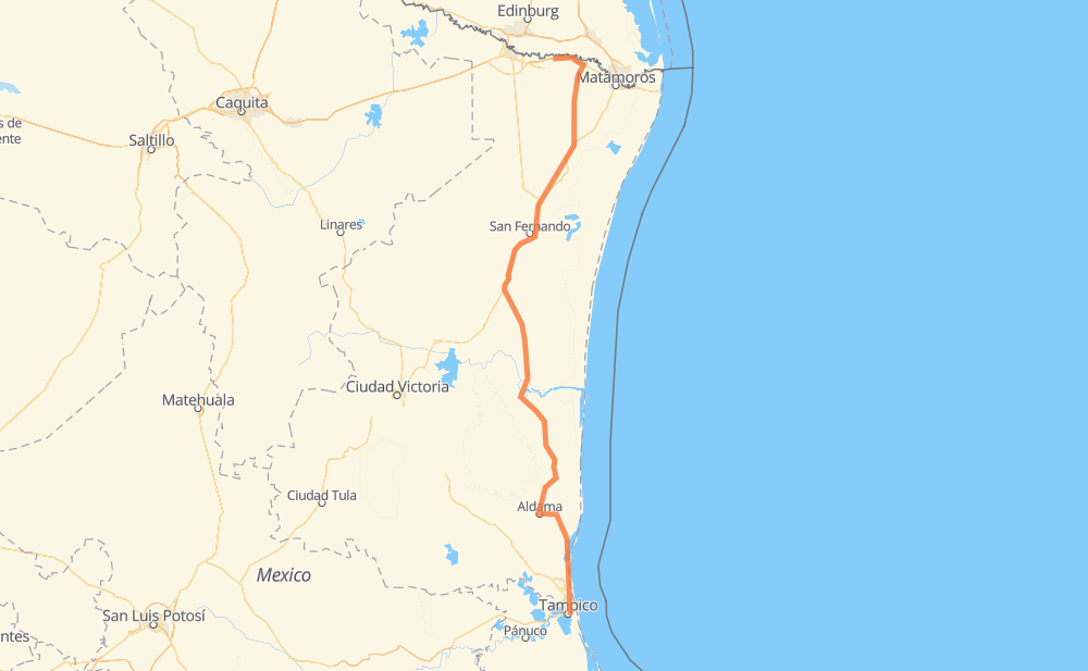
Distance between Tampico and Nuevo Progreso
The distance from Tampico to Nuevo Progreso is 523 kilometers by road including 23 kilometers on motorways. Road takes approximately 6 hours and 7 minutes and goes through Ciudad Madero, Aldama, Anáhuac, Altamira, General Francisco Villa and Valle Hermoso.
| Shortest distance by air | 427 km ✈️ |
| Car route length | 523 km 🚗 |
| Driving time | 6 h 7 min |
| Fuel amount | 41.9 L |
| Fuel cost | 75.4 AUD |
| Toll roads cost | 38 MXN |
| Point | Distance | Time | Fuel | |
| Anáhuac | 0 km | 00 min | 0.0 L | |
|
4 km, 03 min
|
||||
| Ciudad Madero | 4 km | 03 min | 0.1 L | |
|
MEX 180 16 km, 11 min
|
||||
| Altamira | 21 km | 14 min | 1.1 L | |
|
MEX 80 TAM 113 92 km, 1 h 06 min
|
||||
| Aldama | 113 km | 1 h 20 min | 7.8 L | |
|
MEX 180 116 km, 1 h 17 min
|
||||
| Soto la Marina | 229 km | 2 h 38 min | 18.0 L | |
|
MEX 180 151 km, 1 h 40 min
|
||||
| General Francisco Villa | 379 km | 4 h 19 min | 29.8 L | |
|
MEX 101 27 km, 18 min
|
||||
| Alfredo V. Bonfil | 407 km | 4 h 37 min | 32.4 L | |
|
MEX 101 5 km, 03 min
|
||||
| San Germán | 412 km | 4 h 40 min | 32.7 L | |
|
MEX 101 55 km, 41 min
|
||||
| Valle Hermoso | 466 km | 5 h 22 min | 37.0 L | |
|
TAM 53 65 km, 45 min
|
||||
| Nuevo Progreso | 531 km | 6 h 07 min | 42.3 L | |
Frequently Asked Questions
How many toll booths are there from Tampico to Nuevo Progreso?
There are 1 tollbooth between Tampico and Nuevo Progreso: Nuevo Progreso.
How much does the toll booths cost from Tampico to Nuevo Progreso?
Toll roads cost: Nuevo Progreso (38 MXN) = 38 MXN
How much does it cost to drive from Tampico to Nuevo Progreso?
Fuel cost: 75.4 AUD
This fuel cost is calculated as: (Route length 523 km / 100 km) * (Fuel consumption 8 L/100 km) * (Fuel price 1.8 AUD / L)
You can adjust fuel consumption and fuel price here.
Toll roads cost: 38 MXN
How long is a car ride from Tampico to Nuevo Progreso?
Driving time: 6 h 7 min
This time is calculated for driving at the maximum permitted speed, taking into account traffic rules restrictions.
- 23 km with a maximum speed 110 km/h = 12 min
- 372 km with a maximum speed 90 km/h = 4 h 8 min
- 120 km with a maximum speed 80 km/h = 1 h 30 min
- 11 km with a maximum speed 60 km/h = 11 min
- 3 km with a maximum speed 40 km/h = 4 min
The calculated driving time does not take into account intermediate stops and traffic jams.
How far is Tampico to Nuevo Progreso by land?
The distance between Tampico and Nuevo Progreso is 523 km by road including 23 km on motorways.
Precise satellite coordinates of highways were used for this calculation. The start and finish points are the centers of Tampico and Nuevo Progreso respectively.
How far is Tampico to Nuevo Progreso by plane?
The shortest distance (air line, as the crow flies) between Tampico and Nuevo Progreso is 427 km.
This distance is calculated using the Haversine formula as a great-circle distance between two points on the surface of a sphere. The start and finish points are the centers of Tampico and Nuevo Progreso respectively. Actual distance between airports may be different.
How many hours is Tampico from Nuevo Progreso by plane?
Boeing 737 airliner needs 32 min to cover the distance of 427 km at a cruising speed of 800 km/h.
Small plane "Cessna 172" needs 1 h 56 min to flight this distance at average speed of 220 km/h.
This time is approximate and do not take into account takeoff and landing times, airport location and other real world factors.
How long is a helicopter ride from Tampico to Nuevo Progreso?
Fast helicopter "Eurocopter AS350" or "Hughes OH-6 Cayuse" need 1 h 46 min to cover the distance of 427 km at a cruising speed of 240 km/h.
Popular "Robinson R44" needs 2 h 2 min to flight this distance at average speed of 210 km/h.
This time is approximate and do not take into account takeoff and landing times, aerodrome location and other real world factors.
What city is halfway between Tampico and Nuevo Progreso?
The halfway point between Tampico and Nuevo Progreso is Soto la Marina. It is located about 33 km from the exact midpoint by road.
The distance from Soto la Marina to Tampico is 229 km and driving will take about 2 h 38 min. The road between Soto la Marina and Nuevo Progreso has length 295 km and will take approximately 3 h 29 min.
Where is Tampico in relation to Nuevo Progreso?
Tampico is located 427 km south of Nuevo Progreso.
Tampico has geographic coordinates: latitude 22.21705, longitude -97.84637.
Nuevo Progreso has geographic coordinates: latitude 26.05441, longitude -97.95181.
Which highway goes from Tampico to Nuevo Progreso?
The route from Tampico to Nuevo Progreso follows MEX 180, MEX 101.
Other minor sections pass along the road:
- TAM 113: 58 km
- TAM 53: 54 km
- MEX 2D: 23 km
- MEX 80: 17 km
- MEX 2: 10 km
- TAM 47: 2 km