Distance between Teopisca and Otatal
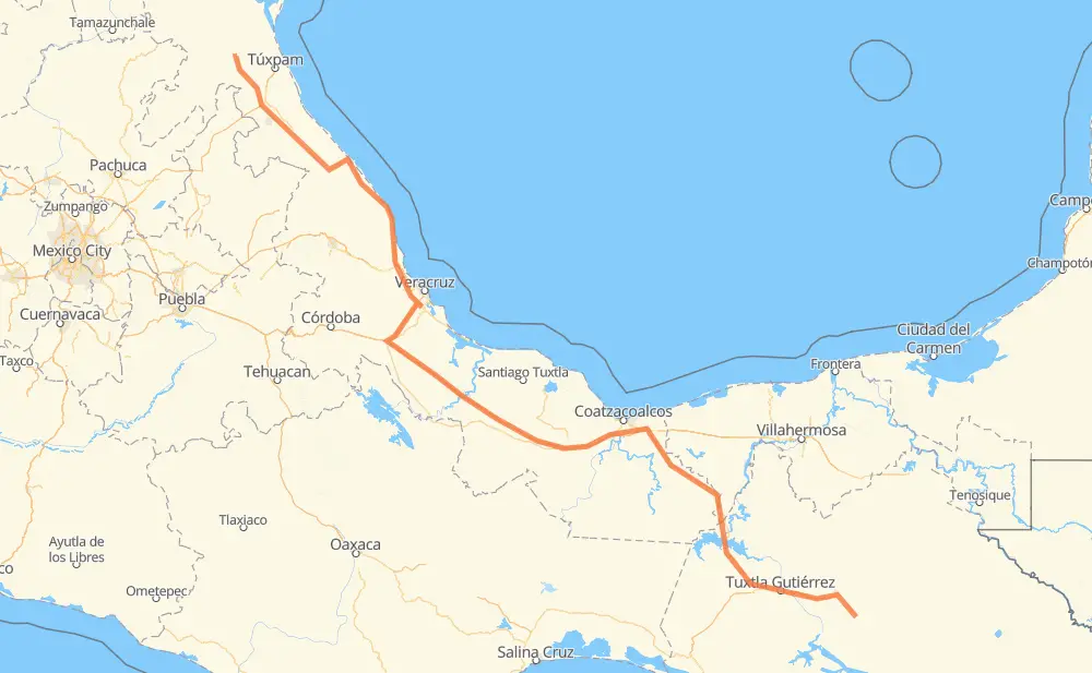
The distance from Teopisca to Otatal is 965 kilometers by road including 330 kilometers on motorways. Road takes approximately 10 hours and 51 minutes and goes through Tuxtla Gutiérrez, Benito Juárez, San Felipe, Chiapa de Corzo, Ocozocuautla, José Cardel and Álamo.
| Shortest distance by air | 747 km ✈️ |
| Car route length | 965 km 🚗 |
| Driving time | 10 h 51 min |
| Fuel amount | 77.2 L |
| Fuel cost | 139.7 AUD |
| Toll roads cost | 783 + ? MXN |
| Point | Distance | Time | Fuel | |
| 16.54146, -92.47265 | 0 km | 00 min | 0.0 L | |
|
MEX 190 11 km, 08 min
|
||||
| Benito Juárez | 11 km | 08 min | 0.2 L | |
|
MEX 190 37 km, 26 min
|
||||
| San Felipe | 48 km | 35 min | 2.8 L | |
|
MEX 190D 28 km, 20 min
|
||||
| Chiapa de Corzo | 76 km | 55 min | 5.9 L | |
|
MEX 190D MEX 190 16 km, 11 min
|
||||
| Tuxtla Gutiérrez | 93 km | 1 h 06 min | 7.3 L | |
|
MEX 190 14 km, 10 min
|
||||
| El Sabino | 107 km | 1 h 17 min | 8.3 L | |
|
MEX 190 6 km, 04 min
|
||||
| Ocozocuautla | 113 km | 1 h 21 min | 9.1 L | |
|
MEX 190 MEX 180D 216 km, 2 h 27 min
|
||||
| Ixhuatlán del Sureste | 330 km | 3 h 49 min | 26.0 L | |
|
MEX 180D MEX 145D 343 km, 3 h 32 min
|
||||
| José Cardel | 673 km | 7 h 21 min | 53.9 L | |
|
MEX 180 278 km, 3 h 19 min
|
||||
| Álamo | 951 km | 10 h 41 min | 75.6 L | |
|
MEX 180 13 km, 10 min
|
||||
| Otatal | 965 km | 10 h 51 min | 77.2 L | |
Frequently Asked Questions
How many toll booths are there from Teopisca to Otatal?
There are 13 toll booths between Teopisca and Otatal: Chapopote, Tuxpan, Cardel - Posa Rica, Nautla, La Antigua, San Julián, Cosamaloapan, Acayucan, Antonio Dovali, Las Choapas, Ocozocoautla 182, Malpasito and Chiapa de Corzo.
How much does the toll booths cost from Teopisca to Otatal?
Toll roads cost: Chiapa de Corzo (53 MXN) + Ocozocoautla 182 (82 MXN) + Malpasito (82 MXN) + Las Choapas (82 MXN) + Antonio Dovali (20 MXN) + Acayucan (?) + Cosamaloapan (229 MXN) + San Julián (?) + La Antigua (?) + Nautla (24 MXN) + Cardel - Posa Rica (205 MXN) + Tuxpan (6 MXN) + Chapopote (?) = 783 + ? MXN
How much does it cost to drive from Teopisca to Otatal?
Fuel cost: 139.7 AUD
This fuel cost is calculated as: (Route length 965 km / 100 km) * (Fuel consumption 8 L/100 km) * (Fuel price 1.81 AUD / L)
You can adjust fuel consumption and fuel price here.
Toll roads cost: 783 + ? MXN
How long is a car ride from Teopisca to Otatal?
Driving time: 10 h 51 min
This time is calculated for driving at the maximum permitted speed, taking into account traffic rules restrictions.
- 24 km with a maximum speed 110 km/h = 13 min
- 258 km with a maximum speed 100 km/h = 2 h 34 min
- 353 km with a maximum speed 90 km/h = 3 h 55 min
- 328 km with a maximum speed 80 km/h = 4 h 5 min
- 2 km with a maximum speed 50 km/h = 2 min
The calculated driving time does not take into account intermediate stops and traffic jams.
How far is Teopisca to Otatal by land?
The distance between Teopisca and Otatal is 965 km by road including 330 km on motorways.
Precise satellite coordinates of highways were used for this calculation. The start and finish points are the centers of Teopisca and Otatal respectively.
How far is Teopisca to Otatal by plane?
The shortest distance (air line, as the crow flies) between Teopisca and Otatal is 747 km.
This distance is calculated using the Haversine formula as a great-circle distance between two points on the surface of a sphere. The start and finish points are the centers of Teopisca and Otatal respectively. Actual distance between airports may be different.
How many hours is Teopisca from Otatal by plane?
Boeing 737 airliner needs 56 min to cover the distance of 747 km at a cruising speed of 800 km/h.
Small plane "Cessna 172" needs 3 h 23 min to flight this distance at average speed of 220 km/h.
This time is approximate and do not take into account takeoff and landing times, airport location and other real world factors.
How long is a helicopter ride from Teopisca to Otatal?
Fast helicopter "Eurocopter AS350" or "Hughes OH-6 Cayuse" need 3 h 6 min to cover the distance of 747 km at a cruising speed of 240 km/h.
Popular "Robinson R44" needs 3 h 33 min to flight this distance at average speed of 210 km/h.
This time is approximate and do not take into account takeoff and landing times, aerodrome location and other real world factors.
What city is halfway between Teopisca and Otatal?
The halfway point between Teopisca and Otatal is Pichoapa. It is located about 14 km from the exact midpoint by road.
The distance from Pichoapa to Teopisca is 496 km and driving will take about 5 h 31 min. The road between Pichoapa and Otatal has length 469 km and will take approximately 5 h 20 min.
The other cities located close to halfway point:
Where is Teopisca in relation to Otatal?
Teopisca is located 747 km south-east of Otatal.
Teopisca has geographic coordinates: latitude 16.54146, longitude -92.47265.
Otatal has geographic coordinates: latitude 21.05361, longitude -97.72917.
Which highway goes from Teopisca to Otatal?
The route from Teopisca to Otatal follows MEX 180D, MEX 145D, MEX 180.
Other minor sections pass along the road:
- MEX 190: 50 km
- MEX 190D: 48 km
- MEX 150D: 44 km
- MEX 127: 32 km
- MEX 129: 23 km
- MEX 130: 4 km
- MEX 132: 4 km