Distance between Tulcingo de Valle and Estrella de Oriente
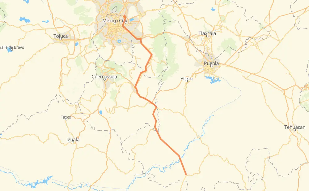
The distance from Tulcingo de Valle to Estrella de Oriente is 242 kilometers by road including 44 kilometers on motorways. Road takes approximately 2 hours and 59 minutes and goes through Ciudad de Chiautla de Tapia, Axochiapan, Jonacatepec, Atlatlahucan, San Miguel Neplanta de Sor Juana Inés de la Cruz, Tepetlixpa and Chalco de Díaz Covarrubias.
| Shortest distance by air | 173 km ✈️ |
| Car route length | 242 km 🚗 |
| Driving time | 2 h 59 min |
| Fuel amount | 19.4 L |
| Fuel cost | 35 AUD |
| Toll roads cost | 75 MXN |
| Point | Distance | Time | Fuel | |
| Tulcingo de Valle | 0 km | 00 min | 0.0 L | |
|
43 km, 31 min
|
||||
| Ciudad de Chiautla de Tapia | 43 km | 31 min | 2.4 L | |
|
43 km, 33 min
|
||||
| Axochiapan | 86 km | 1 h 04 min | 6.5 L | |
|
MOR 031 16 km, 13 min
|
||||
| Jonacatepec | 102 km | 1 h 18 min | 7.8 L | |
|
MEX 160 47 km, 33 min
|
||||
| Atlatlahucan | 149 km | 1 h 52 min | 11.5 L | |
|
MEX 115 15 km, 11 min
|
||||
| Tepetlixpa | 164 km | 2 h 03 min | 12.3 L | |
|
MEX 115 35 km, 24 min
|
||||
| Chalco de Díaz Covarrubias | 199 km | 2 h 28 min | 15.6 L | |
|
MEX 115 4 km, 03 min
|
||||
| Ixtapaluca | 203 km | 2 h 31 min | 16.1 L | |
|
MEX 150D 12 km, 07 min
|
||||
| La Paz | 215 km | 2 h 38 min | 16.9 L | |
|
MEX 150D Periférico 27 km, 20 min
|
||||
| Estrella de Oriente | 242 km | 2 h 59 min | 19.2 L | |
Frequently Asked Questions
How many toll booths are there from Tulcingo de Valle to Estrella de Oriente?
There are 2 toll booths between Tulcingo de Valle and Estrella de Oriente: Ozumba and Ixtapaluca.
How much does the toll booths cost from Tulcingo de Valle to Estrella de Oriente?
Toll roads cost: Ozumba (53 MXN) + Ixtapaluca (22 MXN) = 75 MXN
How much does it cost to drive from Tulcingo de Valle to Estrella de Oriente?
Fuel cost: 35 AUD
This fuel cost is calculated as: (Route length 242 km / 100 km) * (Fuel consumption 8 L/100 km) * (Fuel price 1.81 AUD / L)
You can adjust fuel consumption and fuel price here.
Toll roads cost: 75 MXN
How long is a car ride from Tulcingo de Valle to Estrella de Oriente?
Driving time: 2 h 59 min
This time is calculated for driving at the maximum permitted speed, taking into account traffic rules restrictions.
- 9 km with a maximum speed 110 km/h = 4 min
- 3 km with a maximum speed 100 km/h = 1 min
- 60 km with a maximum speed 90 km/h = 40 min
- 159 km with a maximum speed 80 km/h = 1 h 59 min
- 10 km with a maximum speed 50 km/h = 11 min
The calculated driving time does not take into account intermediate stops and traffic jams.
How far is Tulcingo de Valle to Estrella de Oriente by land?
The distance between Tulcingo de Valle and Estrella de Oriente is 242 km by road including 44 km on motorways.
Precise satellite coordinates of highways were used for this calculation. The start and finish points are the centers of Tulcingo de Valle and Estrella de Oriente respectively.
How far is Tulcingo de Valle to Estrella de Oriente by plane?
The shortest distance (air line, as the crow flies) between Tulcingo de Valle and Estrella de Oriente is 173 km.
This distance is calculated using the Haversine formula as a great-circle distance between two points on the surface of a sphere. The start and finish points are the centers of Tulcingo de Valle and Estrella de Oriente respectively. Actual distance between airports may be different.
How many hours is Tulcingo de Valle from Estrella de Oriente by plane?
Boeing 737 airliner needs 12 min to cover the distance of 173 km at a cruising speed of 800 km/h.
Small plane "Cessna 172" needs 47 min to flight this distance at average speed of 220 km/h.
This time is approximate and do not take into account takeoff and landing times, airport location and other real world factors.
How long is a helicopter ride from Tulcingo de Valle to Estrella de Oriente?
Fast helicopter "Eurocopter AS350" or "Hughes OH-6 Cayuse" need 43 min to cover the distance of 173 km at a cruising speed of 240 km/h.
Popular "Robinson R44" needs 49 min to flight this distance at average speed of 210 km/h.
This time is approximate and do not take into account takeoff and landing times, aerodrome location and other real world factors.
What city is halfway between Tulcingo de Valle and Estrella de Oriente?
The halfway point between Tulcingo de Valle and Estrella de Oriente is Amayuca. It is located about 1 km from the exact midpoint by road.
The distance from Amayuca to Tulcingo de Valle is 122 km and driving will take about 1 h 32 min. The road between Amayuca and Estrella de Oriente has length 120 km and will take approximately 1 h 26 min.
The other cities located close to halfway point:
Where is Tulcingo de Valle in relation to Estrella de Oriente?
Tulcingo de Valle is located 173 km south-east of Estrella de Oriente.
Tulcingo de Valle has geographic coordinates: latitude 18.04582, longitude -98.44111.
Estrella de Oriente has geographic coordinates: latitude 19.49624, longitude -99.02515.
Which highway goes from Tulcingo de Valle to Estrella de Oriente?
The route from Tulcingo de Valle to Estrella de Oriente follows MEX 115.
Other minor sections pass along the road:
- MEX 160: 32 km
- MEX 150D: 14 km
- Periférico: 10 km
- MOR 031: 2 km