Distance between Tupi and Santa Cruz
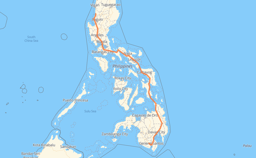
The distance from Tupi to Santa Cruz is 1,974 kilometers by road including 255 kilometers on motorways. Road takes approximately 27 hours and 45 minutes and goes through Digos, Davao City, Bayugan, Surigao City, Tacloban, Catbalogan and Calbayog.
| Shortest distance by air | 1,292 km ✈️ |
| Car route length | 1,974 km 🚗 |
| Driving time | 27 h 45 min |
| Fuel amount | 157.9 L |
| Fuel cost | 285.9 AUD |
| Point | Distance | Time | Fuel | |
| Tupi | 0 km | 00 min | 0.0 L | |
|
1 118 km, 1 h 33 min
|
||||
| Digos | 118 km | 1 h 33 min | 9.3 L | |
|
923 AH26 60 km, 57 min
|
||||
| Davao City | 178 km | 2 h 30 min | 12.1 L | |
|
1 249 km, 3 h 17 min
|
||||
| Bayugan | 427 km | 5 h 48 min | 32.6 L | |
|
1 139 km, 1 h 54 min
|
||||
| Surigao City | 566 km | 7 h 43 min | 45.2 L | |
|
1 228 km, 3 h 51 min
|
||||
| Tacloban | 795 km | 11 h 34 min | 63.3 L | |
|
1 100 km, 1 h 22 min
|
||||
| Catbalogan | 895 km | 12 h 57 min | 70.5 L | |
|
1 83 km, 1 h 15 min
|
||||
| Calbayog | 978 km | 14 h 12 min | 76.2 L | |
|
1 145 km, 2 h 43 min
|
||||
| Sorsogon City | 1,123 km | 16 h 55 min | 89.6 L | |
|
1 81 km, 1 h 00 min
|
||||
| Ligao | 1,204 km | 17 h 56 min | 96.0 L | |
|
1 61 km, 51 min
|
||||
| Naga | 1,266 km | 18 h 47 min | 100.9 L | |
|
1 301 km, 3 h 55 min
|
||||
| San Pablo | 1,566 km | 22 h 43 min | 124.8 L | |
|
1 AH26 34 km, 25 min
|
||||
| Calamba | 1,600 km | 23 h 08 min | 127.6 L | |
|
E2 6 km, 03 min
|
||||
| Cabuyao | 1,607 km | 23 h 12 min | 128.5 L | |
|
E2 3 km, 01 min
|
||||
| Santa Rosa | 1,610 km | 23 h 14 min | 128.6 L | |
|
E2 7 km, 03 min
|
||||
| Biñan | 1,616 km | 23 h 18 min | 129.0 L | |
|
E2 5 km, 03 min
|
||||
| San Pedro | 1,622 km | 23 h 21 min | 129.6 L | |
|
E2 E1 294 km, 3 h 25 min
|
||||
| San Fernando | 1,916 km | 26 h 47 min | 153.2 L | |
|
2 65 km, 57 min
|
||||
| Santa Cruz | 1,981 km | 27 h 45 min | 158.2 L | |
Frequently Asked Questions
How much does it cost to drive from Tupi to Santa Cruz?
Fuel cost: 285.9 AUD
This fuel cost is calculated as: (Route length 1,974 km / 100 km) * (Fuel consumption 8 L/100 km) * (Fuel price 1.81 AUD / L)
You can adjust fuel consumption and fuel price here.
How long is a car ride from Tupi to Santa Cruz?
Driving time: 27 h 45 min
This time is calculated for driving at the maximum permitted speed, taking into account traffic rules restrictions.
- 245 km with a maximum speed 100 km/h = 2 h 26 min
- 184 km with a maximum speed 90 km/h = 2 h 2 min
- 1,126 km with a maximum speed 80 km/h = 14 h 4 min
- 19 km with a maximum speed 70 km/h = 16 min
- 251 km with a maximum speed 60 km/h = 4 h 11 min
- 78 km with a maximum speed 50 km/h = 1 h 34 min
- 25 km with a maximum speed 40 km/h = 37 min
- 6 km with a maximum speed 30 km/h = 11 min
- 47 km with a maximum speed 20 km/h = 2 h 21 min
The calculated driving time does not take into account intermediate stops and traffic jams.
How far is Tupi to Santa Cruz by land?
The distance between Tupi and Santa Cruz is 1,974 km by road including 255 km on motorways.
Precise satellite coordinates of highways were used for this calculation. The start and finish points are the centers of Tupi and Santa Cruz respectively.
How far is Tupi to Santa Cruz by plane?
The shortest distance (air line, as the crow flies) between Tupi and Santa Cruz is 1,292 km.
This distance is calculated using the Haversine formula as a great-circle distance between two points on the surface of a sphere. The start and finish points are the centers of Tupi and Santa Cruz respectively. Actual distance between airports may be different.
How many hours is Tupi from Santa Cruz by plane?
Boeing 737 airliner needs 1 h 36 min to cover the distance of 1,292 km at a cruising speed of 800 km/h.
Small plane "Cessna 172" needs 5 h 52 min to flight this distance at average speed of 220 km/h.
This time is approximate and do not take into account takeoff and landing times, airport location and other real world factors.
How long is a helicopter ride from Tupi to Santa Cruz?
Fast helicopter "Eurocopter AS350" or "Hughes OH-6 Cayuse" need 5 h 23 min to cover the distance of 1,292 km at a cruising speed of 240 km/h.
Popular "Robinson R44" needs 6 h 9 min to flight this distance at average speed of 210 km/h.
This time is approximate and do not take into account takeoff and landing times, aerodrome location and other real world factors.
What city is halfway between Tupi and Santa Cruz?
The halfway point between Tupi and Santa Cruz is Calbayog. It is located about 9 km from the exact midpoint by road.
The distance from Calbayog to Tupi is 978 km and driving will take about 14 h 10 min. The road between Calbayog and Santa Cruz has length 996 km and will take approximately 13 h 34 min.
The other cities located close to halfway point:
Where is Tupi in relation to Santa Cruz?
Tupi is located 1,292 km south-east of Santa Cruz.
Tupi has geographic coordinates: latitude 6.33108, longitude 124.95088.
Santa Cruz has geographic coordinates: latitude 17.08468, longitude 120.45479.
Which highway goes from Tupi to Santa Cruz?
The route from Tupi to Santa Cruz follows AH26, 1, E1, 2.
Other minor sections pass along the road:
- 68: 93 km
- E2: 51 km
- 691: 39 km
- 913: 18 km
- 609: 8 km
- 931: 6 km
- 140: 5 km
- 923: 5 km
- 673: 4 km
- 160: 4 km
- 608: 3 km
- 145: 2 km
- 161: 1 km