Distance between Ulmoris NM and Cuatrociénegas de Carranza
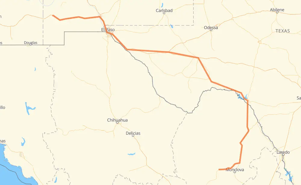
The distance from Ulmoris to Cuatrociénegas de Carranza is 1,304 kilometers by road including 691 kilometers on motorways. Road takes approximately 14 hours and 6 minutes and goes through El Paso, Del Rio, Ciudad Acuña, Lordsburg, Deming, Las Cruces and Socorro.
| Shortest distance by air | 869 km ✈️ |
| Car route length | 1,304 km 🚗 |
| Driving time | 14 h 6 min |
| Fuel amount | 104.3 L |
| Fuel cost | 182.6 AUD |
| Toll roads cost | 0 + ? |
| Point | Distance | Time | Fuel | |
| Ulmoris | 0 km | 00 min | 0.0 L | |
|
5 km, 05 min
|
||||
| Lordsburg | 5 km | 05 min | 0.0 L | |
|
US 70 I 10 94 km, 1 h 08 min
|
||||
| Deming | 99 km | 1 h 13 min | 7.5 L | |
|
I 10 86 km, 47 min
|
||||
| Las Cruces | 185 km | 2 h 00 min | 13.6 L | |
|
I 10 79 km, 46 min
|
||||
| El Paso | 263 km | 2 h 47 min | 20.6 L | |
|
Loop 375 30 km, 18 min
|
||||
| Socorro | 294 km | 3 h 06 min | 23.3 L | |
|
I 10 349 km, 3 h 17 min
|
||||
| Fort Stockton | 643 km | 6 h 23 min | 50.6 L | |
|
I 10 US 90 304 km, 3 h 27 min
|
||||
| Del Rio | 946 km | 9 h 51 min | 75.2 L | |
|
US 90 8 km, 06 min
|
||||
| Ciudad Acuña | 955 km | 9 h 57 min | 76.2 L | |
|
MEX 2 MEX 29 350 km, 4 h 08 min
|
||||
| Cuatrociénegas de Carranza | 1,304 km | 14 h 06 min | 104.2 L | |
Hotels of Cuatrociénegas de Carranza
Frequently Asked Questions
How many toll booths are there from Ulmoris to Cuatrociénegas de Carranza?
There are 1 tollbooth between Ulmoris and Cuatrociénegas de Carranza: Autopista Premier.
How much does the toll booths cost from Ulmoris to Cuatrociénegas de Carranza?
Toll roads cost: Autopista Premier (?) = 0 + ?
How much does it cost to drive from Ulmoris to Cuatrociénegas de Carranza?
Fuel cost: 182.6 AUD
This fuel cost is calculated as: (Route length 1,304 km / 100 km) * (Fuel consumption 8 L/100 km) * (Fuel price 1.75 AUD / L)
You can adjust fuel consumption and fuel price here.
Toll roads cost: 0 + ?
How long is a car ride from Ulmoris to Cuatrociénegas de Carranza?
Driving time: 14 h 6 min
This time is calculated for driving at the maximum permitted speed, taking into account traffic rules restrictions.
- 405 km with a maximum speed 110 km/h = 3 h 40 min
- 31 km with a maximum speed 105 km/h = 17 min
- 136 km with a maximum speed 100 km/h = 1 h 21 min
- 22 km with a maximum speed 97 km/h = 13 min
- 456 km with a maximum speed 90 km/h = 5 h 3 min
- 216 km with a maximum speed 80 km/h = 2 h 42 min
- 1 km with a maximum speed 72 km/h = 1 min
- 17 km with a maximum speed 60 km/h = 16 min
- 17 km with a maximum speed 50 km/h = 19 min
- 3 km with a maximum speed 30 km/h = 6 min
The calculated driving time does not take into account intermediate stops and traffic jams.
How far is Ulmoris to Cuatrociénegas de Carranza by land?
The distance between Ulmoris and Cuatrociénegas de Carranza is 1,304 km by road including 691 km on motorways.
Precise satellite coordinates of highways were used for this calculation. The start and finish points are the centers of Ulmoris and Cuatrociénegas de Carranza respectively.
How far is Ulmoris to Cuatrociénegas de Carranza by plane?
The shortest distance (air line, as the crow flies) between Ulmoris and Cuatrociénegas de Carranza is 869 km.
This distance is calculated using the Haversine formula as a great-circle distance between two points on the surface of a sphere. The start and finish points are the centers of Ulmoris and Cuatrociénegas de Carranza respectively. Actual distance between airports may be different.
How many hours is Ulmoris from Cuatrociénegas de Carranza by plane?
Boeing 737 airliner needs 1 h 5 min to cover the distance of 869 km at a cruising speed of 800 km/h.
Small plane "Cessna 172" needs 3 h 57 min to flight this distance at average speed of 220 km/h.
This time is approximate and do not take into account takeoff and landing times, airport location and other real world factors.
How long is a helicopter ride from Ulmoris to Cuatrociénegas de Carranza?
Fast helicopter "Eurocopter AS350" or "Hughes OH-6 Cayuse" need 3 h 37 min to cover the distance of 869 km at a cruising speed of 240 km/h.
Popular "Robinson R44" needs 4 h 8 min to flight this distance at average speed of 210 km/h.
This time is approximate and do not take into account takeoff and landing times, aerodrome location and other real world factors.
What city is halfway between Ulmoris and Cuatrociénegas de Carranza?
The halfway point between Ulmoris and Cuatrociénegas de Carranza is Fort Stockton. It is located about 10 km from the exact midpoint by road.
The distance from Fort Stockton to Ulmoris is 643 km and driving will take about 6 h 23 min. The road between Fort Stockton and Cuatrociénegas de Carranza has length 662 km and will take approximately 7 h 43 min.
The other cities located close to halfway point:
Where is Ulmoris in relation to Cuatrociénegas de Carranza?
Ulmoris is located 869 km north-west of Cuatrociénegas de Carranza.
Ulmoris has geographic coordinates: latitude 32.32897, longitude -108.63227.
Cuatrociénegas de Carranza has geographic coordinates: latitude 26.98808, longitude -102.06305.
Which highway goes from Ulmoris to Cuatrociénegas de Carranza?
The route from Ulmoris to Cuatrociénegas de Carranza follows I 10, US 90, US 70, US 180, US 285, MEX 29.
Other minor sections pass along the road:
- MEX 57: 95 km
- MEX 30: 55 km
- MEX 57D: 52 km
- Loop 375: 33 km
- US 85: 22 km
- COAH 34: 21 km
- COAH 306: 14 km
- US 67: 13 km
- US 277: 7 km
- US 377: 7 km
- TX 17: 3 km
- US 277 Spur: 3 km
- MEX 2: 3 km
- I 10-G Business: 2 km
- Spur 239: 1 km