Distance between Unhais-o-Velho and Amêndoa
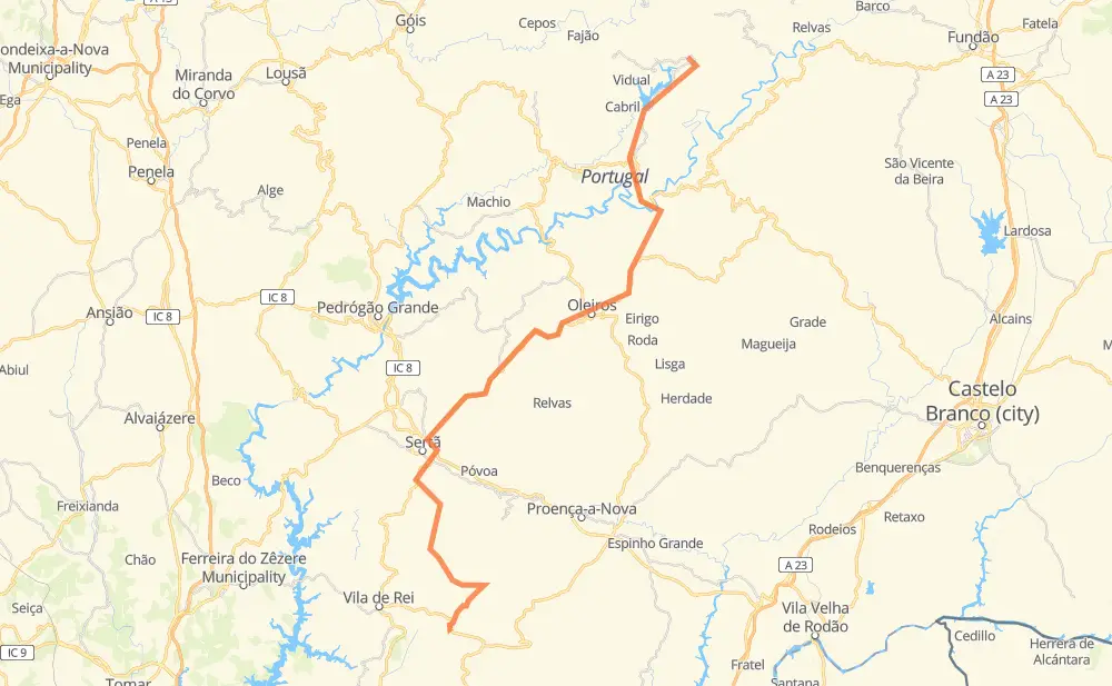
The distance from Unhais-o-Velho to Amêndoa is 88 kilometers by road. Road takes approximately 1 hour and 14 minutes and goes through Pampilhosa da Serra, Oleiros, Sertã, Mosteiro, Troviscal, Marmeleiro and São João do Peso.
| Shortest distance by air | 57 km ✈️ |
| Car route length | 88 km 🚗 |
| Driving time | 1 h 14 min |
| Fuel amount | 7.1 L |
| Fuel cost | 12.6 AUD |
| Point | Distance | Time | Fuel | |
| Unhais-o-Velho | 0 km | 00 min | 0.0 L | |
|
EN 344 2 km, 01 min
|
||||
| Portela de Unhais | 2 km | 01 min | 0.1 L | |
|
EN 344 32 km, 25 min
|
||||
| Oleiros | 34 km | 27 min | 1.8 L | |
|
EN 238 11 km, 09 min
|
||||
| Mosteiro | 45 km | 36 min | 3.6 L | |
|
EN 238 7 km, 05 min
|
||||
| Troviscal | 52 km | 42 min | 4.0 L | |
|
EN 238 12 km, 09 min
|
||||
| Sertã | 64 km | 51 min | 4.7 L | |
|
EN 2 EM 244 8 km, 07 min
|
||||
| Marmeleiro | 72 km | 58 min | 5.5 L | |
|
EM 244 5 km, 06 min
|
||||
| São João do Peso | 77 km | 1 h 05 min | 6.0 L | |
|
EM 244 6 km, 05 min
|
||||
| Cardigos | 84 km | 1 h 11 min | 6.4 L | |
|
EM 244 5 km, 03 min
|
||||
| Amêndoa | 88 km | 1 h 14 min | 7.0 L | |
Frequently Asked Questions
How much does it cost to drive from Unhais-o-Velho to Amêndoa?
Fuel cost: 12.6 AUD
This fuel cost is calculated as: (Route length 88 km / 100 km) * (Fuel consumption 8 L/100 km) * (Fuel price 1.78 AUD / L)
You can adjust fuel consumption and fuel price here.
How long is a car ride from Unhais-o-Velho to Amêndoa?
Driving time: 1 h 14 min
This time is calculated for driving at the maximum permitted speed, taking into account traffic rules restrictions.
- 17 km with a maximum speed 90 km/h = 11 min
- 50 km with a maximum speed 80 km/h = 37 min
- 21 km with a maximum speed 50 km/h = 25 min
The calculated driving time does not take into account intermediate stops and traffic jams.
How far is Unhais-o-Velho to Amêndoa by land?
The distance between Unhais-o-Velho and Amêndoa is 88 km by road.
Precise satellite coordinates of highways were used for this calculation. The start and finish points are the centers of Unhais-o-Velho and Amêndoa respectively.
How far is Unhais-o-Velho to Amêndoa by plane?
The shortest distance (air line, as the crow flies) between Unhais-o-Velho and Amêndoa is 57 km.
This distance is calculated using the Haversine formula as a great-circle distance between two points on the surface of a sphere. The start and finish points are the centers of Unhais-o-Velho and Amêndoa respectively. Actual distance between airports may be different.
How many hours is Unhais-o-Velho from Amêndoa by plane?
Boeing 737 airliner needs 4 min to cover the distance of 57 km at a cruising speed of 800 km/h.
Small plane "Cessna 172" needs 15 min to flight this distance at average speed of 220 km/h.
This time is approximate and do not take into account takeoff and landing times, airport location and other real world factors.
How long is a helicopter ride from Unhais-o-Velho to Amêndoa?
Fast helicopter "Eurocopter AS350" or "Hughes OH-6 Cayuse" need 14 min to cover the distance of 57 km at a cruising speed of 240 km/h.
Popular "Robinson R44" needs 16 min to flight this distance at average speed of 210 km/h.
This time is approximate and do not take into account takeoff and landing times, aerodrome location and other real world factors.
What city is halfway between Unhais-o-Velho and Amêndoa?
Where is Unhais-o-Velho in relation to Amêndoa?
Unhais-o-Velho is located 57 km north-east of Amêndoa.
Unhais-o-Velho has geographic coordinates: latitude 40.13139, longitude -7.81044.
Amêndoa has geographic coordinates: latitude 39.65782, longitude -8.06615.
Which highway goes from Unhais-o-Velho to Amêndoa?
The route from Unhais-o-Velho to Amêndoa follows EN 238.
Other minor sections pass along the road:
- EM 244: 21 km
- EN 344: 15 km
- ER 112: 7 km
- EN 2: 3 km
- IC 8: 1 km