Distance between Upper Sackville NS and Brookfield NS
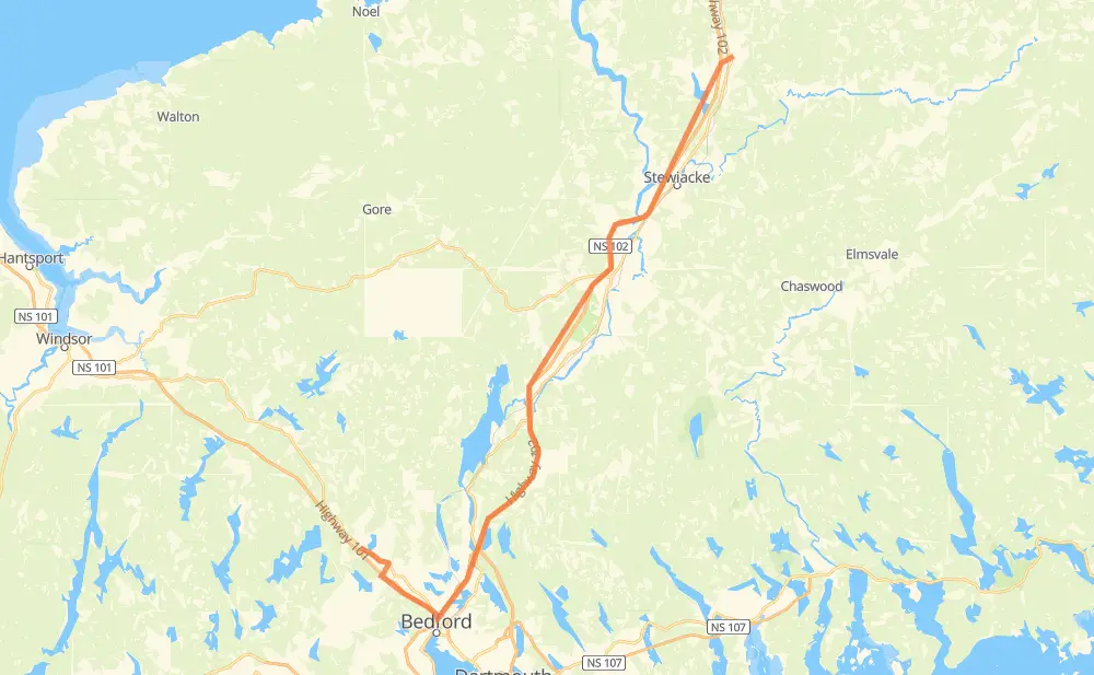
The distance from Upper Sackville to Brookfield is 82 kilometers by road including 76 kilometers on motorways. Road takes approximately 48 minutes and goes through Lower Sackville, Bedford, Middle Sackville, Lakeview, Enfield, Elmsdale and Milford.
| Shortest distance by air | 62 km ✈️ |
| Car route length | 82 km 🚗 |
| Driving time | 48 min |
| Fuel amount | 6.5 L |
| Fuel cost | 11.4 AUD |
| Point | Distance | Time | Fuel | |
| Upper Sackville | 0 km | 00 min | 0.0 L | |
|
NS 1 2 km, 01 min
|
||||
| Middle Sackville | 2 km | 01 min | 0.0 L | |
|
NS 1 NS 101 7 km, 05 min
|
||||
| Lower Sackville | 9 km | 07 min | 0.5 L | |
|
NS 101 5 km, 03 min
|
||||
| Bedford | 14 km | 10 min | 0.9 L | |
|
NS 102 4 km, 02 min
|
||||
| Lakeview | 17 km | 12 min | 1.3 L | |
|
NS 102 24 km, 13 min
|
||||
| Enfield | 41 km | 25 min | 3.0 L | |
|
NS 102 13 km, 06 min
|
||||
| Milford | 54 km | 32 min | 4.1 L | |
|
NS 102 28 km, 15 min
|
||||
| Brookfield | 82 km | 48 min | 6.5 L | |
Frequently Asked Questions
How much does it cost to drive from Upper Sackville to Brookfield?
Fuel cost: 11.4 AUD
This fuel cost is calculated as: (Route length 82 km / 100 km) * (Fuel consumption 8 L/100 km) * (Fuel price 1.75 AUD / L)
You can adjust fuel consumption and fuel price here.
How long is a car ride from Upper Sackville to Brookfield?
Driving time: 48 min
This time is calculated for driving at the maximum permitted speed, taking into account traffic rules restrictions.
- 58 km with a maximum speed 110 km/h = 31 min
- 17 km with a maximum speed 100 km/h = 10 min
- 3 km with a maximum speed 80 km/h = 1 min
- 3 km with a maximum speed 60 km/h = 3 min
The calculated driving time does not take into account intermediate stops and traffic jams.
How far is Upper Sackville to Brookfield by land?
The distance between Upper Sackville and Brookfield is 82 km by road including 76 km on motorways.
Precise satellite coordinates of highways were used for this calculation. The start and finish points are the centers of Upper Sackville and Brookfield respectively.
How far is Upper Sackville to Brookfield by plane?
The shortest distance (air line, as the crow flies) between Upper Sackville and Brookfield is 62 km.
This distance is calculated using the Haversine formula as a great-circle distance between two points on the surface of a sphere. The start and finish points are the centers of Upper Sackville and Brookfield respectively. Actual distance between airports may be different.
How many hours is Upper Sackville from Brookfield by plane?
Boeing 737 airliner needs 4 min to cover the distance of 62 km at a cruising speed of 800 km/h.
Small plane "Cessna 172" needs 16 min to flight this distance at average speed of 220 km/h.
This time is approximate and do not take into account takeoff and landing times, airport location and other real world factors.
How long is a helicopter ride from Upper Sackville to Brookfield?
Fast helicopter "Eurocopter AS350" or "Hughes OH-6 Cayuse" need 15 min to cover the distance of 62 km at a cruising speed of 240 km/h.
Popular "Robinson R44" needs 17 min to flight this distance at average speed of 210 km/h.
This time is approximate and do not take into account takeoff and landing times, aerodrome location and other real world factors.
What city is halfway between Upper Sackville and Brookfield?
The halfway point between Upper Sackville and Brookfield is Enfield.
The distance from Enfield to Upper Sackville is 41 km and driving will take about 25 min. The road between Enfield and Brookfield has length 41 km and will take approximately 22 min.
The other cities located close to halfway point:
Where is Upper Sackville in relation to Brookfield?
Upper Sackville is located 62 km south-west of Brookfield.
Upper Sackville has geographic coordinates: latitude 44.80831, longitude -63.75557.
Brookfield has geographic coordinates: latitude 45.25478, longitude -63.27575.
Which highway goes from Upper Sackville to Brookfield?
The route from Upper Sackville to Brookfield follows NS 102.
Other minor sections pass along the road:
- NS 101: 7 km
- NS 1: 4 km
- NS 289: 1 km