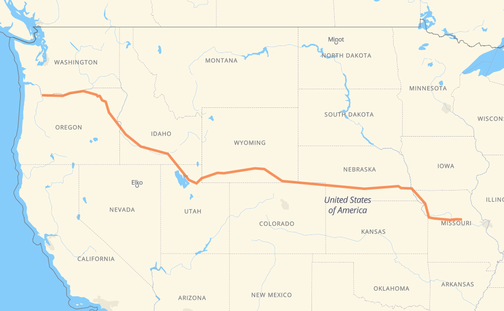
The distance from Vancouver to Lindbergh is 3,111 kilometers by road including 3,022 kilometers on motorways. Road takes approximately 29 hours and 27 minutes and goes through Portland, Ogden, Rock Springs, Laramie, Cheyenne, North Platte and Lincoln.
How much does it cost to drive from Vancouver to Lindbergh?
Fuel cost:
448 AUD
This fuel cost is calculated as: (Route length 3,111 km / 100 km) * (Fuel consumption 8 L/100 km) * (Fuel price 1.8 AUD / L)
You can adjust fuel consumption and fuel price here.
How long is a car ride from Vancouver to Lindbergh?
Driving time:
29 h 27 min
This time is calculated for driving at the maximum permitted speed, taking into account traffic rules restrictions.
2,359 km with a maximum speed 110 km/h = 21 h 26 min
225 km with a maximum speed 105 km/h = 2 h 8 min
218 km with a maximum speed 100 km/h = 2 h 10 min
38 km with a maximum speed 97 km/h = 23 min
66 km with a maximum speed 90 km/h = 44 min
38 km with a maximum speed 89 km/h = 25 min
2 km with a maximum speed 80 km/h = 1 min
152 km with a maximum speed 80 km/h = 1 h 54 min
11 km with a maximum speed 72 km/h = 9 min
1 km with a maximum speed 40 km/h = 1 min
The calculated driving time does not take into account intermediate stops and traffic jams.
How far is Vancouver to Lindbergh by land?
The distance between Vancouver and Lindbergh is 3,111 km by road including 3,022 km on motorways.
Precise satellite coordinates of highways were used for this calculation. The start and finish points are the centers of Vancouver and Lindbergh respectively.
How far is Vancouver to Lindbergh by plane?
The shortest distance (air line, as the crow flies) between Vancouver and Lindbergh is 2,603 km.
This distance is calculated using the Haversine formula as a great-circle distance between two points on the surface of a sphere. The start and finish points are the centers of Vancouver and Lindbergh respectively. Actual distance between airports may be different.
How many hours is Vancouver from Lindbergh by plane?
Boeing 737 airliner needs 3 h 15 min to cover the distance of 2,603 km at a cruising speed of 800 km/h.
Small plane "Cessna 172" needs 11 h 49 min to flight this distance at average speed of 220 km/h.
This time is approximate and do not take into account takeoff and landing times, airport location and other real world factors.
How long is a helicopter ride from Vancouver to Lindbergh?
Fast helicopter "Eurocopter AS350" or "Hughes OH-6 Cayuse" need 10 h 50 min to cover the distance of 2,603 km at a cruising speed of 240 km/h.
Popular "Robinson R44" needs 12 h 23 min to flight this distance at average speed of 210 km/h.
This time is approximate and do not take into account takeoff and landing times, aerodrome location and other real world factors.
What city is halfway between Vancouver and Lindbergh?
The halfway point between Vancouver and Lindbergh is Red Desert. It is located about 9 km from the exact midpoint by road.
The distance from Red Desert to Vancouver is 1,564 km and driving will take about 15 h 3 min. The road between Red Desert and Lindbergh has length 1,547 km and will take approximately 14 h 23 min.
The other cities located close to halfway point:
Wamsutter is in 1,577 km from Vancouver and 1,533 km from Lindbergh
Creston Junction is in 1,593 km from Vancouver and 1,518 km from Lindbergh
Point of Rocks is in 1,502 km from Vancouver and 1,609 km from Lindbergh
Where is Vancouver in relation to Lindbergh?
Vancouver is located 2,603 km west of Lindbergh.
Vancouver has geographic coordinates: latitude 45.6307, longitude -122.67446.
Lindbergh has geographic coordinates: latitude 38.95586, longitude -92.12824.
Which highway goes from Vancouver to Lindbergh?
The route from Vancouver to Lindbergh follows I 80, I 84, US 30, I 70, I 29, US 40, US 26.