Distance between Villa Matamoros and Calamanda
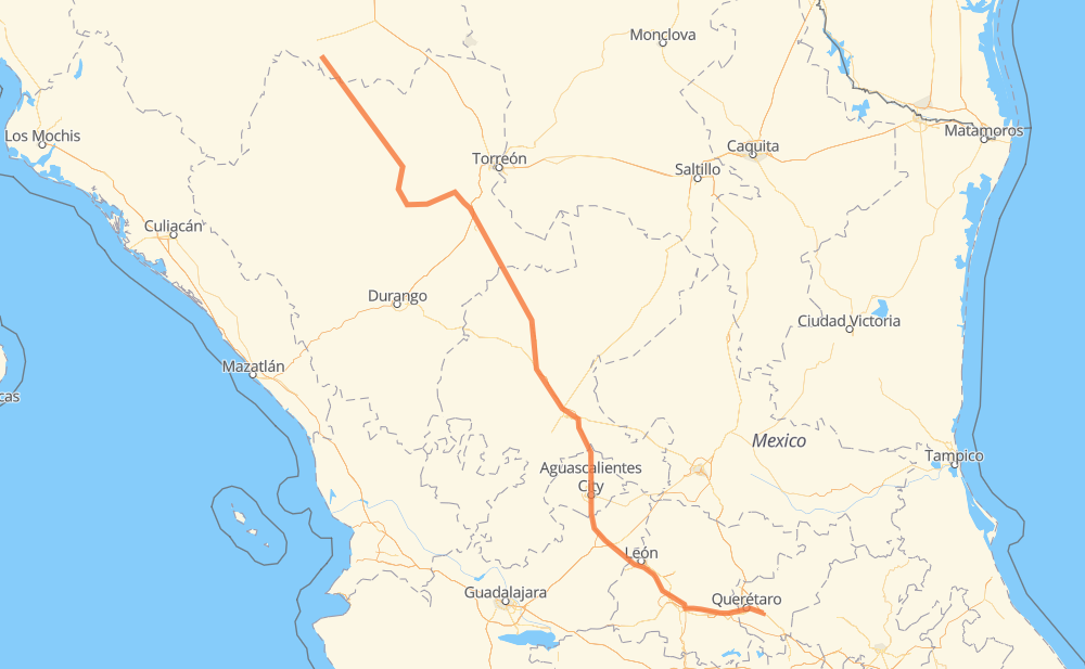
The distance from Villa Matamoros to Calamanda is 1,065 kilometers by road including 312 kilometers on motorways. Road takes approximately 11 hours and 39 minutes and goes through Fresnillo, Aguascalientes, Salamanca, Celaya and Querétaro.
| Shortest distance by air | 883 km ✈️ |
| Car route length | 1,065 km 🚗 |
| Driving time | 11 h 39 min |
| Fuel amount | 85.2 L |
| Fuel cost | 154.2 AUD |
| Toll roads cost | 590 + ? MXN |
| Point | Distance | Time | Fuel | |
| Villa Matamoros | 0 km | 00 min | 0.0 L | |
|
MEX 45 53 km, 40 min
|
||||
| Villa Las Nieves | 53 km | 40 min | 3.9 L | |
|
MEX 45 13 km, 10 min
|
||||
| Torreón de Cañas | 65 km | 50 min | 5.2 L | |
|
MEX 45 29 km, 18 min
|
||||
| Revolución | 94 km | 1 h 09 min | 7.2 L | |
|
MEX 45 MEX 49 484 km, 5 h 30 min
|
||||
| Fresnillo | 578 km | 6 h 40 min | 45.4 L | |
|
MEX 45D 178 km, 1 h 58 min
|
||||
| Aguascalientes | 756 km | 8 h 39 min | 60.1 L | |
|
MEX 70 MEX 45D 205 km, 1 h 58 min
|
||||
| Salamanca | 961 km | 10 h 37 min | 76.9 L | |
|
MEX 45D 31 km, 18 min
|
||||
| Celaya | 992 km | 10 h 56 min | 79.0 L | |
|
MEX 45D 46 km, 25 min
|
||||
| Querétaro | 1,038 km | 11 h 22 min | 82.6 L | |
|
MEX 45D MEX 45 26 km, 17 min
|
||||
| Calamanda | 1,065 km | 11 h 39 min | 85.1 L | |
Frequently Asked Questions
How many toll booths are there from Villa Matamoros to Calamanda?
There are 10 toll booths between Villa Matamoros and Calamanda: Morfín Chávez, Calera, Veta Grande, Zacatecas, Encarnacion De Diaz, León - Aguascalientes, Puerto Interior, Mendoza, Cerro Gordo and Querétaro 6.
How much does the toll booths cost from Villa Matamoros to Calamanda?
Toll roads cost: Morfín Chávez (40 MXN) + Calera (23 MXN) + Veta Grande (48 MXN) + Zacatecas (41 MXN) + Encarnacion De Diaz (150 MXN) + León - Aguascalientes (153 MXN) + Puerto Interior (?) + Mendoza (53 MXN) + Cerro Gordo (?) + Querétaro 6 (82 MXN) = 590 + ? MXN
How much does it cost to drive from Villa Matamoros to Calamanda?
Fuel cost: 154.2 AUD
This fuel cost is calculated as: (Route length 1,065 km / 100 km) * (Fuel consumption 8 L/100 km) * (Fuel price 1.81 AUD / L)
You can adjust fuel consumption and fuel price here.
Toll roads cost: 590 + ? MXN
How long is a car ride from Villa Matamoros to Calamanda?
Driving time: 11 h 39 min
This time is calculated for driving at the maximum permitted speed, taking into account traffic rules restrictions.
- 242 km with a maximum speed 110 km/h = 2 h 11 min
- 45 km with a maximum speed 100 km/h = 27 min
- 575 km with a maximum speed 90 km/h = 6 h 23 min
- 193 km with a maximum speed 80 km/h = 2 h 24 min
- 2 km with a maximum speed 60 km/h = 2 min
- 2 km with a maximum speed 50 km/h = 2 min
- 4 km with a maximum speed 40 km/h = 5 min
- 1 km with a maximum speed 30 km/h = 1 min
The calculated driving time does not take into account intermediate stops and traffic jams.
How far is Villa Matamoros to Calamanda by land?
The distance between Villa Matamoros and Calamanda is 1,065 km by road including 312 km on motorways.
Precise satellite coordinates of highways were used for this calculation. The start and finish points are the centers of Villa Matamoros and Calamanda respectively.
How far is Villa Matamoros to Calamanda by plane?
The shortest distance (air line, as the crow flies) between Villa Matamoros and Calamanda is 883 km.
This distance is calculated using the Haversine formula as a great-circle distance between two points on the surface of a sphere. The start and finish points are the centers of Villa Matamoros and Calamanda respectively. Actual distance between airports may be different.
How many hours is Villa Matamoros from Calamanda by plane?
Boeing 737 airliner needs 1 h 6 min to cover the distance of 883 km at a cruising speed of 800 km/h.
Small plane "Cessna 172" needs 4 h to flight this distance at average speed of 220 km/h.
This time is approximate and do not take into account takeoff and landing times, airport location and other real world factors.
How long is a helicopter ride from Villa Matamoros to Calamanda?
Fast helicopter "Eurocopter AS350" or "Hughes OH-6 Cayuse" need 3 h 40 min to cover the distance of 883 km at a cruising speed of 240 km/h.
Popular "Robinson R44" needs 4 h 12 min to flight this distance at average speed of 210 km/h.
This time is approximate and do not take into account takeoff and landing times, aerodrome location and other real world factors.
What city is halfway between Villa Matamoros and Calamanda?
The halfway point between Villa Matamoros and Calamanda is Río Grande. It is located about 34 km from the exact midpoint by road.
The distance from Río Grande to Villa Matamoros is 498 km and driving will take about 5 h 48 min. The road between Río Grande and Calamanda has length 567 km and will take approximately 5 h 51 min.
The other cities located close to halfway point:
Where is Villa Matamoros in relation to Calamanda?
Villa Matamoros is located 883 km north-west of Calamanda.
Villa Matamoros has geographic coordinates: latitude 26.76449, longitude -105.58471.
Calamanda has geographic coordinates: latitude 20.54694, longitude -100.1875.
Which highway goes from Villa Matamoros to Calamanda?
The route from Villa Matamoros to Calamanda follows MEX 45, MEX 45D, MEX 49.
Other minor sections pass along the road:
- MEX 34: 97 km
- MEX 43D: 77 km
- MEX 70: 53 km
- MEX 40: 23 km
- MEX 57: 15 km
- MEX 45: 5 km
- MEX 54: 1 km