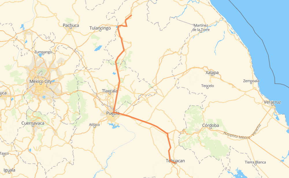
Distance between Xicotepec de Juárez and Tehuacán
The distance from Xicotepec de Juárez to Tehuacán is 297 kilometers by road including 148 kilometers on motorways. Road takes approximately 3 hours and 28 minutes and goes through Acatzingo de Hidalgo, Palmarito Tochapan, Cuacnopalan, San José Ixtapa and Santiago Miahuatlán.
| Shortest distance by air | 210 km ✈️ |
| Car route length | 297 km 🚗 |
| Driving time | 3 h 28 min |
| Fuel amount | 23.8 L |
| Fuel cost | 41.8 AUD |
| Toll roads cost | 72 + ? MXN |
| Point | Distance | Time | Fuel | |
| Xicotepec de Juárez | 0 km | 00 min | 0.0 L | |
|
MEX 130 25 km, 19 min
|
||||
| Xilocuautla | 25 km | 19 min | 1.8 L | |
|
MEX 130D 12 km, 09 min
|
||||
| La Bóveda | 38 km | 28 min | 2.9 L | |
|
MEX 119 MEX 119D 5 km, 03 min
|
||||
| Beristáin | 43 km | 31 min | 3.3 L | |
|
MEX 119D 178 km, 1 h 59 min
|
||||
| Acatzingo de Hidalgo | 221 km | 2 h 30 min | 17.3 L | |
|
MEX 150D 14 km, 09 min
|
||||
| Palmarito Tochapan | 235 km | 2 h 40 min | 18.6 L | |
|
MEX 150D 13 km, 09 min
|
||||
| Cuacnopalan | 248 km | 2 h 49 min | 19.1 L | |
|
MEX 150D 16 km, 12 min
|
||||
| San José Ixtapa | 264 km | 3 h 01 min | 20.6 L | |
|
MEX 135D 15 km, 11 min
|
||||
| Santiago Miahuatlán | 279 km | 3 h 12 min | 21.7 L | |
|
MEX 135D 22 km, 15 min
|
||||
| Tehuacán | 301 km | 3 h 27 min | 23.7 L | |
Hotels of Tehuacán
Frequently Asked Questions
How many toll booths are there from Xicotepec de Juárez to Tehuacán?
There are 6 toll booths between Xicotepec de Juárez and Tehuacán: Viaducto Elevado de Puebla, Amozoc, Tehuacán, Michac and Tejocotal.
How much does the toll booths cost from Xicotepec de Juárez to Tehuacán?
Toll roads cost: Tejocotal (?) + Michac (?) + Viaducto Elevado de Puebla (?) + Viaducto Elevado de Puebla (?) + Amozoc (72 MXN) + Tehuacán (?) = 72 + ? MXN
How much does it cost to drive from Xicotepec de Juárez to Tehuacán?
Fuel cost: 41.8 AUD
This fuel cost is calculated as: (Route length 297 km / 100 km) * (Fuel consumption 8 L/100 km) * (Fuel price 1.76 AUD / L)
You can adjust fuel consumption and fuel price here.
Toll roads cost: 72 + ? MXN
How long is a car ride from Xicotepec de Juárez to Tehuacán?
Driving time: 3 h 28 min
This time is calculated for driving at the maximum permitted speed, taking into account traffic rules restrictions.
- 27 km with a maximum speed 110 km/h = 14 min
- 31 km with a maximum speed 100 km/h = 18 min
- 103 km with a maximum speed 90 km/h = 1 h 8 min
- 134 km with a maximum speed 80 km/h = 1 h 40 min
- 3 km with a maximum speed 70 km/h = 2 min
- 1 km with a maximum speed 60 km/h = 1 min
- 2 km with a maximum speed 50 km/h = 2 min
The calculated driving time does not take into account intermediate stops and traffic jams.
How far is Xicotepec de Juárez to Tehuacán by land?
The distance between Xicotepec de Juárez and Tehuacán is 297 km by road including 148 km on motorways.
Precise satellite coordinates of highways were used for this calculation. The start and finish points are the centers of Xicotepec de Juárez and Tehuacán respectively.
How far is Xicotepec de Juárez to Tehuacán by plane?
The shortest distance (air line, as the crow flies) between Xicotepec de Juárez and Tehuacán is 210 km.
This distance is calculated using the Haversine formula as a great-circle distance between two points on the surface of a sphere. The start and finish points are the centers of Xicotepec de Juárez and Tehuacán respectively. Actual distance between airports may be different.
How many hours is Xicotepec de Juárez from Tehuacán by plane?
Boeing 737 airliner needs 15 min to cover the distance of 210 km at a cruising speed of 800 km/h.
Small plane "Cessna 172" needs 57 min to flight this distance at average speed of 220 km/h.
This time is approximate and do not take into account takeoff and landing times, airport location and other real world factors.
How long is a helicopter ride from Xicotepec de Juárez to Tehuacán?
Fast helicopter "Eurocopter AS350" or "Hughes OH-6 Cayuse" need 52 min to cover the distance of 210 km at a cruising speed of 240 km/h.
Popular "Robinson R44" needs 1 h to flight this distance at average speed of 210 km/h.
This time is approximate and do not take into account takeoff and landing times, aerodrome location and other real world factors.
What city is halfway between Xicotepec de Juárez and Tehuacán?
The halfway point between Xicotepec de Juárez and Tehuacán is San Jacinto. It is located about 37 km from the exact midpoint by road.
The distance from San Jacinto to Xicotepec de Juárez is 186 km and driving will take about 2 h 10 min. The road between San Jacinto and Tehuacán has length 111 km and will take approximately 1 h 17 min.
The other cities located close to halfway point:
Where is Xicotepec de Juárez in relation to Tehuacán?
Xicotepec de Juárez is located 210 km north-west of Tehuacán.
Xicotepec de Juárez has geographic coordinates: latitude 20.27417, longitude -97.955.
Tehuacán has geographic coordinates: latitude 18.45999, longitude -97.39036.