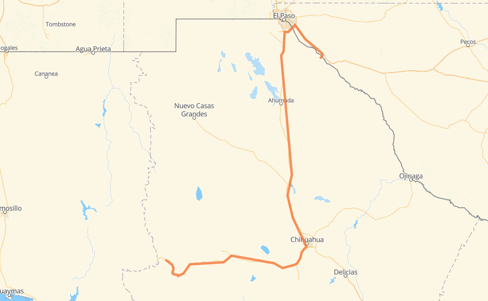
Distance between Yepachic and El Porvenir
The distance from Yepachic to El Porvenir is 764 kilometers by road including 84 kilometers on motorways. Road takes approximately 8 hours and 43 minutes and goes through Cuauhtémoc, Ciudad Juárez, Basaseachi, Páramo de Morelos, Santa Isabel, Rancho de Peña and Villa Ahumada.
| Shortest distance by air | 395 km ✈️ |
| Car route length | 764 km 🚗 |
| Driving time | 8 h 43 min |
| Fuel amount | 61.1 L |
| Fuel cost | 107.5 AUD |
| Toll roads cost | 400 MXN |
| Point | Distance | Time | Fuel | |
| Yepachic | 0 km | 00 min | 0.0 L | |
|
MEX 16 45 km, 31 min
|
||||
| Basaseachi | 45 km | 31 min | 3.2 L | |
|
MEX 16 147 km, 1 h 46 min
|
||||
| Páramo de Morelos | 191 km | 2 h 18 min | 14.3 L | |
|
MEX 16 27 km, 18 min
|
||||
| Cuauhtémoc | 219 km | 2 h 37 min | 16.9 L | |
|
MEX 16 50 km, 33 min
|
||||
| Santa Isabel | 268 km | 3 h 11 min | 20.9 L | |
|
MEX 16 18 km, 12 min
|
||||
| Rancho de Peña | 286 km | 3 h 23 min | 22.1 L | |
|
MEX 16 MEX 45 273 km, 3 h 04 min
|
||||
| Villa Ahumada | 559 km | 6 h 28 min | 44.1 L | |
|
MEX 45 120 km, 1 h 22 min
|
||||
| Ciudad Juárez | 679 km | 7 h 50 min | 53.9 L | |
|
Loop 375 20 km, 12 min
|
||||
| Socorro | 699 km | 8 h 03 min | 55.7 L | |
|
I 10 65 km, 39 min
|
||||
| El Porvenir | 764 km | 8 h 43 min | 60.7 L | |
Frequently Asked Questions
How many toll booths are there from Yepachic to El Porvenir?
There are 4 toll booths between Yepachic and El Porvenir: Zaragoza-Ysleta, Villa Ahumada, Sacramento and Cuauhtémoc.
How much does the toll booths cost from Yepachic to El Porvenir?
Toll roads cost: Cuauhtémoc (110 MXN) + Sacramento (71 MXN) + Villa Ahumada (188 MXN) + Zaragoza-Ysleta (31 MXN) = 400 MXN
How much does it cost to drive from Yepachic to El Porvenir?
Fuel cost: 107.5 AUD
This fuel cost is calculated as: (Route length 764 km / 100 km) * (Fuel consumption 8 L/100 km) * (Fuel price 1.76 AUD / L)
You can adjust fuel consumption and fuel price here.
Toll roads cost: 400 MXN
How long is a car ride from Yepachic to El Porvenir?
Driving time: 8 h 43 min
This time is calculated for driving at the maximum permitted speed, taking into account traffic rules restrictions.
- 57 km with a maximum speed 110 km/h = 31 min
- 19 km with a maximum speed 100 km/h = 11 min
- 3 km with a maximum speed 97 km/h = 2 min
- 487 km with a maximum speed 90 km/h = 5 h 24 min
- 179 km with a maximum speed 80 km/h = 2 h 13 min
- 7 km with a maximum speed 70 km/h = 6 min
- 4 km with a maximum speed 60 km/h = 3 min
- 3 km with a maximum speed 50 km/h = 3 min
- 5 km with a maximum speed 40 km/h = 6 min
The calculated driving time does not take into account intermediate stops and traffic jams.
How far is Yepachic to El Porvenir by land?
The distance between Yepachic and El Porvenir is 764 km by road including 84 km on motorways.
Precise satellite coordinates of highways were used for this calculation. The start and finish points are the centers of Yepachic and El Porvenir respectively.
How far is Yepachic to El Porvenir by plane?
The shortest distance (air line, as the crow flies) between Yepachic and El Porvenir is 395 km.
This distance is calculated using the Haversine formula as a great-circle distance between two points on the surface of a sphere. The start and finish points are the centers of Yepachic and El Porvenir respectively. Actual distance between airports may be different.
How many hours is Yepachic from El Porvenir by plane?
Boeing 737 airliner needs 29 min to cover the distance of 395 km at a cruising speed of 800 km/h.
Small plane "Cessna 172" needs 1 h 47 min to flight this distance at average speed of 220 km/h.
This time is approximate and do not take into account takeoff and landing times, airport location and other real world factors.
How long is a helicopter ride from Yepachic to El Porvenir?
Fast helicopter "Eurocopter AS350" or "Hughes OH-6 Cayuse" need 1 h 38 min to cover the distance of 395 km at a cruising speed of 240 km/h.
Popular "Robinson R44" needs 1 h 52 min to flight this distance at average speed of 210 km/h.
This time is approximate and do not take into account takeoff and landing times, aerodrome location and other real world factors.
What city is halfway between Yepachic and El Porvenir?
The halfway point between Yepachic and El Porvenir is Ejido Nuevo Delicias y Anexas (Tierras Nuevas). It is located about 11 km from the exact midpoint by road.
The distance from Ejido Nuevo Delicias y Anexas (Tierras Nuevas) to Yepachic is 393 km and driving will take about 4 h 36 min. The road between Ejido Nuevo Delicias y Anexas (Tierras Nuevas) and El Porvenir has length 370 km and will take approximately 4 h 6 min.
The other cities located close to halfway point:
Where is Yepachic in relation to El Porvenir?
Yepachic is located 395 km south-west of El Porvenir.
Yepachic has geographic coordinates: latitude 28.42301, longitude -108.37683.
El Porvenir has geographic coordinates: latitude 31.23875, longitude -105.87956.
Which highway goes from Yepachic to El Porvenir?
The route from Yepachic to El Porvenir follows MEX 16, MEX 45.
Other minor sections pass along the road:
- MEX 45D: 97 km
- I 10: 60 km
- MEX 2: 8 km
- CHIH 25: 7 km
- Loop 375: 4 km
- Spur 148: 2 km
- TX 20: 1 km
- FM 1088: 1 km