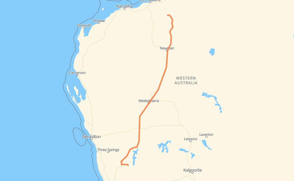
Distance between Kalannie and Marble Bar
The distance from Kalannie to Marble Bar is 1,283 kilometers by road. Road takes approximately 22 hours and 57 minutes and goes through Dalwallinu, Wubin, Mount Magnet, Meekatharra, Karalundi and Nullagine.
| Shortest distance by air | 1,056 km ✈️ |
| Car route length | 1,283 km 🚗 |
| Driving time | 22 h 57 min |
| Fuel amount | 377.2 L |
| Fuel cost | 2,542.1 AUD |
| Point | Distance | Time | Fuel | |
| Kalannie | 0 km | 00 min | 0.0 L | |
|
28 km, 29 min
|
||||
| Dalwallinu | 28 km | 29 min | 0.2 L | |
|
95 78 km, 1 h 23 min
|
||||
| Wubin | 106 km | 1 h 53 min | 16.1 L | |
|
95 121 km, 2 h 09 min
|
||||
| Paynes Find | 227 km | 4 h 02 min | 66.5 L | |
|
95 146 km, 2 h 36 min
|
||||
| Mount Magnet | 373 km | 6 h 39 min | 107.9 L | |
|
95 280 km, 4 h 59 min
|
||||
| Meekatharra | 652 km | 11 h 39 min | 160.9 L | |
|
95 138 km, 2 h 27 min
|
||||
| Kumarina | 790 km | 14 h 06 min | 222.7 L | |
|
95 341 km, 6 h 07 min
|
||||
| Bonney Downs | 1,131 km | 20 h 14 min | 332.4 L | |
|
138 77 km, 1 h 22 min
|
||||
| Nullagine | 1,208 km | 21 h 36 min | 335.6 L | |
|
138 75 km, 1 h 20 min
|
||||
| Marble Bar | 1,283 km | 22 h 57 min | 375.3 L | |
Frequently Asked Questions
How much does it cost to drive from Kalannie to Marble Bar?
Fuel cost: 2,542.1 AUD
This fuel cost is calculated as: (Route length 1,283 km / 100 km) * (Fuel consumption 29.40 L/100 km) * (Fuel price 6.74 AUD / L)
You can adjust fuel consumption and fuel price here.
How long is a car ride from Kalannie to Marble Bar?
Driving time: 22 h 57 min
This time is calculated for driving at the maximum permitted speed, taking into account traffic rules restrictions.
- 1,278 km with a maximum speed 56 km/h = 22 h 49 min
- 4 km with a maximum speed 50 km/h = 4 min
- 1 km with a maximum speed 16 km/h = 3 min
The calculated driving time does not take into account intermediate stops and traffic jams.
How far is Kalannie to Marble Bar by land?
The distance between Kalannie and Marble Bar is 1,283 km by road.
Precise satellite coordinates of highways were used for this calculation. The start and finish points are the centers of Kalannie and Marble Bar respectively.
How far is Kalannie to Marble Bar by plane?
The shortest distance (air line, as the crow flies) between Kalannie and Marble Bar is 1,056 km.
This distance is calculated using the Haversine formula as a great-circle distance between two points on the surface of a sphere. The start and finish points are the centers of Kalannie and Marble Bar respectively. Actual distance between airports may be different.
How many hours is Kalannie from Marble Bar by plane?
Boeing 737 airliner needs 1 h 19 min to cover the distance of 1,056 km at a cruising speed of 800 km/h.
Small plane "Cessna 172" needs 4 h 48 min to flight this distance at average speed of 220 km/h.
This time is approximate and do not take into account takeoff and landing times, airport location and other real world factors.
How long is a helicopter ride from Kalannie to Marble Bar?
Fast helicopter "Eurocopter AS350" or "Hughes OH-6 Cayuse" need 4 h 24 min to cover the distance of 1,056 km at a cruising speed of 240 km/h.
Popular "Robinson R44" needs 5 h 1 min to flight this distance at average speed of 210 km/h.
This time is approximate and do not take into account takeoff and landing times, aerodrome location and other real world factors.
What city is halfway between Kalannie and Marble Bar?
The halfway point between Kalannie and Marble Bar is Meekatharra. It is located about 11 km from the exact midpoint by road.
The distance from Meekatharra to Kalannie is 652 km and driving will take about 11 h 39 min. The road between Meekatharra and Marble Bar has length 631 km and will take approximately 11 h 18 min.
The other cities located close to halfway point:
Where is Kalannie in relation to Marble Bar?
Kalannie is located 1,056 km south-west of Marble Bar.
Kalannie has geographic coordinates: latitude -30.36371, longitude 117.11812.
Marble Bar has geographic coordinates: latitude -21.17149, longitude 119.74562.
Which highway goes from Kalannie to Marble Bar?
The route from Kalannie to Marble Bar follows 95, 138.