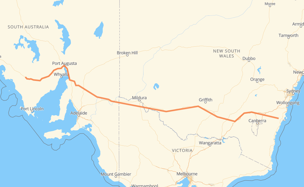
Distance between Boolijah and Wudinna
The distance from Boolijah to Wudinna is 1,751 kilometers by road including 243 kilometers on motorways. Road takes approximately 19 hours and 31 minutes and goes through Wagga Wagga, Mildura, Port Augusta, Tianjara, Nowra Hill, Parma and Yerriyong.
| Shortest distance by air | 1,387 km ✈️ |
| Car route length | 1,751 km 🚗 |
| Driving time | 19 h 31 min |
| Fuel amount | 140.1 L |
| Fuel cost | 252.1 AUD |
| Point | Distance | Time | Fuel | |
| Boolijah | 0 km | 00 min | 0.0 L | |
|
33 km, 30 min
|
||||
| Sassafras | 33 km | 30 min | 2.6 L | |
|
76 km, 52 min
|
||||
| Marulan | 109 km | 1 h 23 min | 7.7 L | |
|
M31 28 km, 16 min
|
||||
| Goulburn | 137 km | 1 h 40 min | 10.4 L | |
|
M31 81 km, 43 min
|
||||
| Yass | 217 km | 2 h 23 min | 16.8 L | |
|
M31 61 km, 33 min
|
||||
| Jugiong | 278 km | 2 h 57 min | 21.9 L | |
|
M31 122 km, 1 h 15 min
|
||||
| Wagga Wagga | 400 km | 4 h 12 min | 31.8 L | |
|
A20 559 km, 6 h 19 min
|
||||
| Mildura | 959 km | 10 h 31 min | 76.1 L | |
|
A20 B64 533 km, 6 h 03 min
|
||||
| Port Augusta | 1,492 km | 16 h 35 min | 119.1 L | |
|
A1 260 km, 2 h 55 min
|
||||
| Wudinna | 1,752 km | 19 h 31 min | 140.0 L | |
Frequently Asked Questions
How much does it cost to drive from Boolijah to Wudinna?
Fuel cost: 252.1 AUD
This fuel cost is calculated as: (Route length 1,751 km / 100 km) * (Fuel consumption 8 L/100 km) * (Fuel price 1.8 AUD / L)
You can adjust fuel consumption and fuel price here.
How long is a car ride from Boolijah to Wudinna?
Driving time: 19 h 31 min
This time is calculated for driving at the maximum permitted speed, taking into account traffic rules restrictions.
- 242 km with a maximum speed 110 km/h = 2 h 12 min
- 1,368 km with a maximum speed 90 km/h = 15 h 12 min
- 93 km with a maximum speed 80 km/h = 1 h 10 min
- 1 km with a maximum speed 70 km/h = 1 min
- 36 km with a maximum speed 60 km/h = 35 min
- 5 km with a maximum speed 50 km/h = 6 min
- 1 km with a maximum speed 25 km/h = 1 min
- 4 km with a maximum speed 20 km/h = 11 min
The calculated driving time does not take into account intermediate stops and traffic jams.
How far is Boolijah to Wudinna by land?
The distance between Boolijah and Wudinna is 1,751 km by road including 243 km on motorways.
Precise satellite coordinates of highways were used for this calculation. The start and finish points are the centers of Boolijah and Wudinna respectively.
How far is Boolijah to Wudinna by plane?
The shortest distance (air line, as the crow flies) between Boolijah and Wudinna is 1,387 km.
This distance is calculated using the Haversine formula as a great-circle distance between two points on the surface of a sphere. The start and finish points are the centers of Boolijah and Wudinna respectively. Actual distance between airports may be different.
How many hours is Boolijah from Wudinna by plane?
Boeing 737 airliner needs 1 h 44 min to cover the distance of 1,387 km at a cruising speed of 800 km/h.
Small plane "Cessna 172" needs 6 h 18 min to flight this distance at average speed of 220 km/h.
This time is approximate and do not take into account takeoff and landing times, airport location and other real world factors.
How long is a helicopter ride from Boolijah to Wudinna?
Fast helicopter "Eurocopter AS350" or "Hughes OH-6 Cayuse" need 5 h 46 min to cover the distance of 1,387 km at a cruising speed of 240 km/h.
Popular "Robinson R44" needs 6 h 36 min to flight this distance at average speed of 210 km/h.
This time is approximate and do not take into account takeoff and landing times, aerodrome location and other real world factors.
What city is halfway between Boolijah and Wudinna?
The halfway point between Boolijah and Wudinna is Balranald. It is located about 52 km from the exact midpoint by road.
The distance from Balranald to Boolijah is 823 km and driving will take about 8 h 56 min. The road between Balranald and Wudinna has length 928 km and will take approximately 10 h 34 min.
The other cities located close to halfway point:
Where is Boolijah in relation to Wudinna?
Boolijah is located 1,387 km east of Wudinna.
Boolijah has geographic coordinates: latitude -35.05861, longitude 150.33222.
Wudinna has geographic coordinates: latitude -33.04724, longitude 135.46157.
Which highway goes from Boolijah to Wudinna?
The route from Boolijah to Wudinna follows A20, A1, M31, B64.
Other minor sections pass along the road:
- B82: 24 km
- B79: 19 km
- A32: 7 km
- B80: 4 km
- A79: 4 km
- A41: 3 km