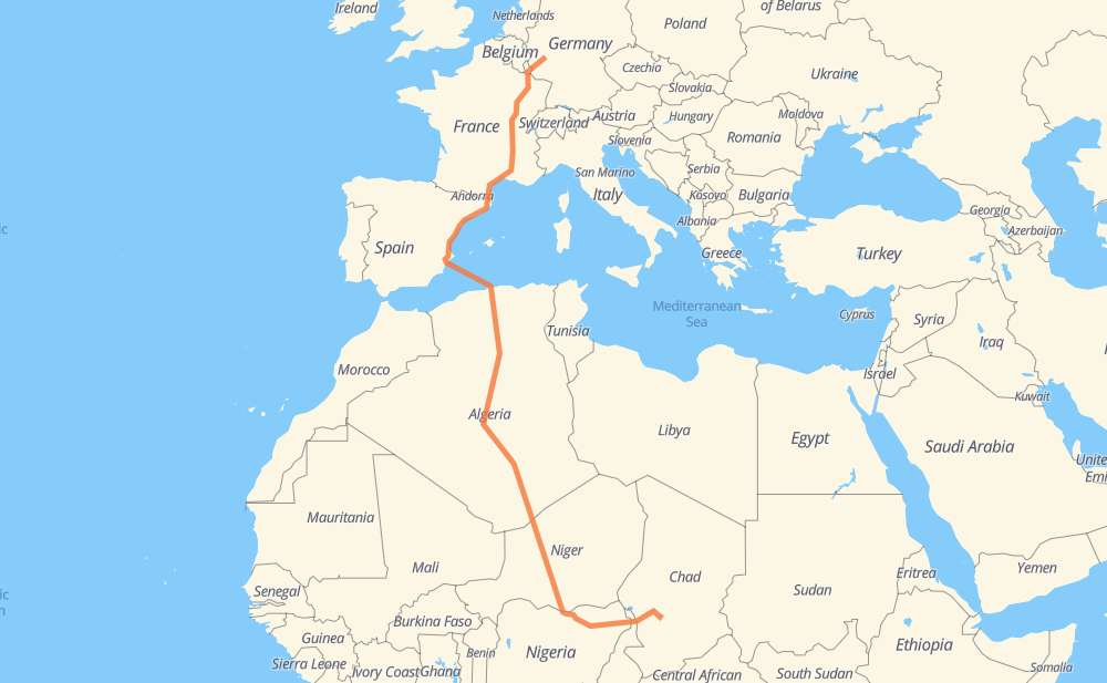
Distance between Coblenza and Nacha
The distance from Coblenza to Nacha is 6,668 kilometers by road including 2,151 kilometers on motorways. Road takes approximately 93 hours and 43 minutes and goes through Luxembourg, Metz, Lyon, Nîmes, Montpellier, Perpiñán and Castellón de la Plana.
| Shortest distance by air | 4,286 km ✈️ |
| Car route length | 6,668 km 🚗 |
| Driving time | 93 h 43 min |
| Fuel amount | 533.4 L |
| Fuel cost | 949.5 AUD |
| Point | Distance | Time | Fuel | |
| Coblenza | 0 km | 00 min | 0.0 L | |
|
B 49 A 1 170 km, 1 h 50 min
|
||||
| Luxembourg | 170 km | 1 h 50 min | 13.2 L | |
|
A 1 A 31 60 km, 38 min
|
||||
| Metz | 230 km | 2 h 28 min | 18.3 L | |
|
A 31 454 km, 4 h 13 min
|
||||
| Lyon | 685 km | 6 h 42 min | 54.5 L | |
|
M 6 A 7 249 km, 2 h 19 min
|
||||
| Nîmes | 934 km | 9 h 02 min | 74.2 L | |
|
A 9 48 km, 25 min
|
||||
| Montpellier | 982 km | 9 h 28 min | 78.2 L | |
|
A 9 151 km, 1 h 22 min
|
||||
| Perpiñán | 1,132 km | 10 h 50 min | 90.1 L | |
|
A 9 AP-7 1,116 km, 25 h 30 min
|
||||
| Blida | 2,249 km | 36 h 21 min | 179.8 L | |
|
A1 RN 1 25 km, 17 min
|
||||
| Medea | 2,273 km | 36 h 39 min | 181.2 L | |
|
RN 1 126 km, 1 h 32 min
|
||||
| Ain Oussara | 2,399 km | 38 h 11 min | 189.8 L | |
|
RN 1 99 km, 1 h 15 min
|
||||
| Djelfa | 2,499 km | 39 h 26 min | 198.2 L | |
|
RN 1 102 km, 1 h 14 min
|
||||
| Laghouat | 2,601 km | 40 h 40 min | 206.7 L | |
|
RN 1 186 km, 2 h 07 min
|
||||
| Ghardaia | 2,787 km | 42 h 48 min | 222.3 L | |
|
RN 1 2,170 km, 27 h 10 min
|
||||
| Arlit | 4,958 km | 69 h 59 min | 396.5 L | |
|
N 25 240 km, 2 h 40 min
|
||||
| Agadez | 5,198 km | 72 h 39 min | 415.6 L | |
|
N 25 N 11 286 km, 3 h 25 min
|
||||
| Tanout | 5,484 km | 76 h 05 min | 438.3 L | |
|
N 11 151 km, 1 h 53 min
|
||||
| Zinder | 5,635 km | 77 h 58 min | 450.7 L | |
|
N 11 81 km, 1 h 00 min
|
||||
| Magaria | 5,716 km | 78 h 59 min | 454.7 L | |
|
N 11 F128 175 km, 2 h 11 min
|
||||
| Hadejia | 5,891 km | 81 h 10 min | 470.6 L | |
|
F.249 F.131 162 km, 2 h 00 min
|
||||
| Potiskum | 6,053 km | 83 h 11 min | 483.8 L | |
|
A3 477 km, 5 h 56 min
|
||||
| Kousséri | 6,529 km | 89 h 07 min | 521.7 L | |
|
N1 359 km, 4 h 34 min
|
||||
| Nacha | 6,888 km | 93 h 42 min | 550.7 L | |
Frequently Asked Questions
How much does it cost to drive from Coblenza to Nacha?
Fuel cost: 949.5 AUD
This fuel cost is calculated as: (Route length 6,668 km / 100 km) * (Fuel consumption 8 L/100 km) * (Fuel price 1.78 AUD / L)
You can adjust fuel consumption and fuel price here.
How long is a car ride from Coblenza to Nacha?
Driving time: 93 h 43 min
This time is calculated for driving at the maximum permitted speed, taking into account traffic rules restrictions.
- 1,464 km with a maximum speed 110 km/h = 13 h 18 min
- 304 km with a maximum speed 100 km/h = 3 h 2 min
- 1,344 km with a maximum speed 90 km/h = 14 h 56 min
- 3,073 km with a maximum speed 80 km/h = 38 h 24 min
- 19 km with a maximum speed 70 km/h = 16 min
- 274 km with a maximum speed 60 km/h = 4 h 33 min
- 38 km with a maximum speed 50 km/h = 46 min
- 5 km with a maximum speed 40 km/h = 7 min
- 1 km with a maximum speed 30 km/h = 2 min
- 365 km with a maximum speed 20 km/h = 18 h 14 min
The calculated driving time does not take into account intermediate stops and traffic jams.
How far is Coblenza to Nacha by land?
The distance between Coblenza and Nacha is 6,668 km by road including 2,151 km on motorways.
Precise satellite coordinates of highways were used for this calculation. The start and finish points are the centers of Coblenza and Nacha respectively.
How far is Coblenza to Nacha by plane?
The shortest distance (air line, as the crow flies) between Coblenza and Nacha is 4,286 km.
This distance is calculated using the Haversine formula as a great-circle distance between two points on the surface of a sphere. The start and finish points are the centers of Coblenza and Nacha respectively. Actual distance between airports may be different.
How many hours is Coblenza from Nacha by plane?
Boeing 737 airliner needs 5 h 21 min to cover the distance of 4,286 km at a cruising speed of 800 km/h.
Small plane "Cessna 172" needs 19 h 28 min to flight this distance at average speed of 220 km/h.
This time is approximate and do not take into account takeoff and landing times, airport location and other real world factors.
How long is a helicopter ride from Coblenza to Nacha?
Fast helicopter "Eurocopter AS350" or "Hughes OH-6 Cayuse" need 17 h 51 min to cover the distance of 4,286 km at a cruising speed of 240 km/h.
Popular "Robinson R44" needs 20 h 24 min to flight this distance at average speed of 210 km/h.
This time is approximate and do not take into account takeoff and landing times, aerodrome location and other real world factors.
What city is halfway between Coblenza and Nacha?
The halfway point between Coblenza and Nacha is In Salah. It is located about 68 km from the exact midpoint by road.
The distance from In Salah to Coblenza is 3,402 km and driving will take about 49 h 59 min. The road between In Salah and Nacha has length 3,266 km and will take approximately 43 h 44 min.
The other cities located close to halfway point:
Where is Coblenza in relation to Nacha?
Coblenza is located 4,286 km north of Nacha.
Coblenza has geographic coordinates: latitude 50.35333, longitude 7.5944.
Nacha has geographic coordinates: latitude 12.61636, longitude 17.12462.
Which highway goes from Coblenza to Nacha?
The route from Coblenza to Nacha follows RN 1, N 25, N 11, AP-7, A3, A 31, A 9, A 7, F.131, A-7, A 6.
Other minor sections pass along the road:
- A 1: 85 km
- F128: 79 km
- N1A: 73 km
- A 48: 59 km
- A1: 40 km
- N1: 27 km
- F.249: 22 km
- V-21: 18 km
- V-31: 14 km
- A 3: 13 km
- A 64: 11 km
- M 6: 10 km
- F.244: 9 km
- A-77: 7 km
- B 52: 6 km
- M 7: 6 km
- B 9: 5 km
- N 1: 4 km
- A-31: 4 km
- A-70: 4 km
- A 602: 4 km
- ط و 1: 2 km
- RN 11: 2 km
- RN 8: 1 km
- F.128-1: 1 km